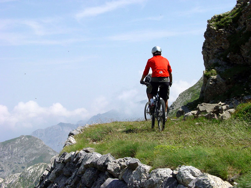
Tour of the Fortresses
Itinerary by mountain bike and on horseback
- Trail Conditions: By bike
- Interest: Flora, Wildlife, Panorama, Hystory, Photography
- Departure: Pian delle Gorre (Valle Pesio) o Upega (Valle Tanaro) (1,000m)
- Duration: 4 days
- Difficulty Level: demanding
- Difference in height: 4,670m
- Recommended Period: from June to August
On the border between Italy and France, from the second half of the 19th century, several fortresses were built. They are connected by a network of mule tracks giving the opportunity to visit the natural beauties of the mountains housing the old war buildings, now abandoned. Given its length, this itinerary is divided into four laps, with the possibility to leave from Upega.
1st Lap
From Certosa di Pesio (859m) reach Pian delle Gorre (1,032m); take the uphill trail on the left leading to Garelli Mountain Hut and reach the Saut; go ahead on the right to Duca Pass. You will get to Gias degli Arpi (1,435m – 7.5 km, fountain). From here onwards, the bottom is more stony and steep. From Colle del Prel (1,925m), a panoramic place, follow the original route, now grassy and easy, avoiding the stretches meeting the trail, which are not accessible by bike. You reach Duca Pass, at 1,989m (9 km from Pian delle Gorre). The natural prosecution of the trail leads, along 2.5 km of trail, sometimes technical, towards Gias dell'Ortica (fountain, 1,855m). Follow the trail marked in the north of the kiosk, and climb, after further 3.5 km and 364m of difference in height, to Colla Piana di Malaberga (Capanna Morgantini), at 2,219m. From here follow downhill the road Limone - Monesi, continue on the left (stony roadbed) and reach Colle del Lago dei Signori (Don Barbera Mountain Hut), in a total of 26 km and 1,500m of uphill trail.
2nd Lap
Continue along the military road touching the 2,290m, after which you will go ahead with a slight downhill trail to Flamalgal Pass, where the gray and heavy limestone give way to a luxuriant green basin; a downhill stretch introduces, after Colle di Selle Vecchie (2,098m), in the larch wood "delle Navette". Alternating open stretches and meadows to the characteristic larch woodland, you will reach Costa Ventosa and therefore Vallone di Tanarello, and in the end Margaria Loxe (1,893m); climb on the right to Tanarello Pass (2,045m 20 km) from which you will go down to Collardente Pass (1,617m 26 km).
From here go ahead uphill on the left (or on the right) up to Bassa di Sanson and then on the left towards Cima di Marta. Go down to Grai Mountains, Valletta, Pietravecchia, and Toraggio, up to Colla Melosa (F.Allavena Mountain Hut, 1,540m) after a total of 42 km and 760m of difference in height.
3rd Lap
Backwards, follow the stretch of itinerary up to Bassa di Sanson (12 km), from here on the left downhill towards La Brigue, in Valle Roja, after touching the wonderful chapel of Notre Dame des Fontaines, from which you can go ahead on the left until you reach La Brigue. From here, in 2 km you will reach S.Dalmas de Tende. Go ahead, after meeting the road to the tunnel of Colle di Tenda, on the left and then on the right uphill after 300m to Casterino. You reach Lac des Mesches and the plateau of Casterino, in the so-called "Valle delle Meraviglie" (The Valley of Wonders) and of the important rupestrian engravings at the gates of Parc National du Mercantour (total 48 km and 1,510m of difference in height).
4th Lap
From Casterino, continue along a demanding dirt road leading to Basse de Peyrefique (7 km 2,020m), touching the slopes of Rocca dell'Abisso. Going beyond fortresses and pastures, you will reach Colle di Tenda (1,971m 14 km).
Continue towards the north-east with a slight descent and reach a junction after a few hundred meters, continue on the right crossing Forte Centrale and, following the road on the north side, you will reach the military road Limone - Monesi. Start the downhill stretch of Bric Campanino reaching Col and Gias della Perla, Col della Boaria and then again uphill until the junction to Capanna Morgantini and Colla Piana di Malabergue, completing the ring-route.
You will reach then Colla Piana di Malabergue (2,220m and 24 km), where the technical trail going down to Gias dell'Ortica begins. Along an uphill trail, reach Duca Pass, where the downhill trail leading from Colle del Prel to Gias degli Arpi, Pian delle Gorre leaves, with a total of 44 km and 920m of difference in height.
Alternative Route
Departure from Upega
The Tour of the Fortresses can also leave from Valle Tanaro, in Upega. Climb towards Colletta delle Salse and, before a few dozen meters from the pass, at Giaireto bridge (recreational area), continue on the right abandoning the asphalt. You reach, after 2.7 km of carriage road across the larches, via Limone Monesi, in Costa Pian dei Termi. From here continue on the left following the itinerary of the below-mentioned second lap leading from Don Barbera to Colle dei Signori and reaches Colla Melosa. Leaving from Upega, add 500m of difference in height with respect to the above-mentioned lap, maintaining the distance of 42 km.
Itinerary
- 1st Lap
26 km - 1,500m of difference in height
Pian delle Gorre 1,000m - Duca Pass 1,989m - Gias dell'Ortica - Capanna Morgantini 2,220m - Don Barbera Mountain Hut 2,109m - 2nd Lap
42 km - 760m of difference in height
Don Barbera Mountain Hut - Flamalgal Pass 2,200m - Margaria Loxe 1,800m - Tanarello Pass 2,200m - Collardente - Colla Melosa, CAI Allavena Mountain Hut 1,540m - 3rd Lap
48 km - 1,510m of difference in height (2,200m of difference in height with alternative route from Tenda)
Colla Melosa, CAI Allavena Mountain Hut - Balcone di Marta 2,090m - S.Dalmas De Tende 780m - Casterino 1,670m - 4th Lap
44 km - 900m of difference in height
Casterino - Basse de Peyrefique 2,020m - Colle di Tenda 1830 m - Capanna Morgantini 2,220m - Gias dell'Ortica - Duca Pass 1,989m - Pian delle Gorre 1,000m