Escursioni a Rossiglione
(Parco del Beigua) |

English text |
 |
 1. Rossiglione - Monte Pavaglione 1. Rossiglione - Monte Pavaglione
- Difficoltà: EM
- Percorrenza: 3.30 h
- Dislivello: 600 m
- Segnavia: rombo pieno giallo - tre tondi gialli disposti a triangolo
- Periodo consigliato: da ottobre a fine maggio evitando i periodi più freddi.
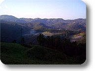
L’itinerario presenta notevole varietà paesaggistica sia dal punto di vista geologico che della vegetazione con tratti panoramici sulla Valle Gargassa oltreché interessanti testimonianze del mondo rurale.
Il percorso inizia presso la stazione ferroviaria di Rossiglione in corrispondenza del ponte metallico che attraversa il torrente Stura. Si attraversa la parte vecchia del paese portandosi fino alla strada statale da cui parte il sentiero in salita che passa sopra al viadotto autostradale. Si prosegue attraverso un bosco misto di roveri e castagni che salendo varia nella sua composizione e diventa a prevalenza di pino marittimo. Si giunge così al nucleo rurale di Case Broglio (456 mt), caratterizzato da piccoli terrazzamenti prativi, superato il quale si risale nel bosco misto di castagni e pini fino a raggiungere Case Albarina. Qui il paesaggio si apre sulla sottostante Valle Gargassa: degno di nota è la presenza autunnale dello zafferano ligure.
Trascurando il segnavia tre tondi gialli disposti a triangolo che individua un sentiero naturalistico a destra, si continua seguendo il rombo giallo lungo la dorsale in un ambiente del tutto differente da quello finora attraversato. Infatti entriamo in una zona caratterizzata dalle scure rocce dei conglomerati ofiolitici, si oltrepassa l’aguzzo costone roccioso del Bric dei Crovi immettendosi in un tratto di traverso a mezza costa: la vegetazione assume un aspetto sempre più xerofilo (erica arborea, calluna, elicriso ed euforbia spinosa) con radi pinastri abbarbicati sulle rocce e presenza di sorbo montano. Dopo essersi riportati prima sul crinale e poi sul lato della Valle Stura si giunge alla Colla Mayolo (520 mt). Da qui, abbandonando i conglomerati e ritornando in ambiente serpentinitico, si sale nuovamente nel bosco a castagni e roveri che via via si diradano sino ad arrivare alle praterie sommitali del Prà Sodato: qui il sentiero svolta a destra oltrepassando un primo rudere e riportandosi sul versante opposto. Si scende così fino a Casa Viotta (670 mt; fonte): questa zona è interessante per la presenza di ciliegi selvatici, castagni da frutto, tassi e faggi. Il tratto successivo che risale verso il crinale presenta nuovamente alberi di rovere, da cui si deduce l’esistenza di un’inversione altitudinale per causa antropica.
La parte finale del percorso attraversa le pendici ovest del Monte Pavaglione lungo un’area adibita a pascolo e incrocia una strada asfaltata proveniente da Campo Ligure. Si prende a destra e si prosegue in salita fino ad incontrare il segnavia tre tondi gialli disposti a triangolo che porta in cima al Pavaglione.
|
|
|
 2. Anello della Valle Gargassa 2. Anello della Valle Gargassa
- Difficoltà: EE
- Percorrenza: 3 h
- Dislivello: 250 m circa
- Segnavia: XX giallo - tre tondi gialli disposti a triangolo - tondo giallo
- Periodo consigliato: tutto l’anno evitando i periodi successivi a forti precipitazioni.
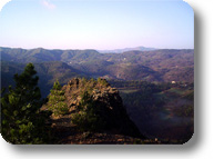
L’itinerario è di notevole interesse geologico con scorci mozzafiato sul canyon della Valle Gargassa.
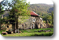
L’itinerario inizia vicino al campo sportivo di Rossiglione con uno stretto sentierino che costeggia il campo sul lato a monte. Dopo un breve tratto in un bosco misto costituito da castagni, noccioli e carpini neri, si superano alcune roccette con l’aiuto di un cavo metallico sino ad arrivare all’inizio vero e proprio della gola. Qui nelle zone prative è possibile praticare agricampeggio contattando l’Azienda Agrituristica Monterosso.
Proseguendo si incontrano sulla destra piante di conifere (prevalentemente pino nero), mentre, sulla sinistra, si stagliano alcuni torrioni di conglomerato con evidenti linee di stratificazione: i clasti si presentano spigolosi indicando una origine autoctona, derivano infatti dalla disgregazione delle rocce serpentinitiche del Monte Beigua che hanno subito un breve trasporto fluviale.
Da qui il sentiero continua in un suggestivo tratto lungo il torrente caratterizzato da scarna vegetazione (elicriso, santoreggia e, negli anfratti meno soleggiati, la rara costolina appenninica) e da limpide pozze smeraldine che in estate invitano ad un bagno rinfrescante e rigenerante.
Si attraversa il rio presso una strettoia delimitata da un curioso affioramento roccioso detto “Muso di Gatto” per poi risalire in un boschetto di castagni e querce superando una fonte dove si può osservare la non comune felce florida. Si guada nuovamente il rio e si giunge in prossimità di Case Veirera (400 m), una vasta piana un tempo utilizzata come coltivo. Da qua, mantenendo la stessa direzione di marcia, è possibile raggiungere in una ventina di minuti una sorgente sulfurea seguendo un sentiero non segnato ma individuabile abbastanza facilmente per la presenza di una indicazione.
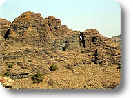
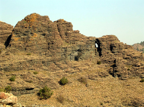
Da Veirera si imbocca il sentiero segnato con tre tondi gialli disposti a triangolo, che sale rapidamente in un bosco misto di roveri fino a portarsi sotto gli arditi torrioni di conglomerato della Rocca dei Corvi (535 m). Si continua orizzontalmente su una labile traccia quasi a strapiombo sul sottostante torrente Gargassa. Da questo punto, particolarmente suggestivo, si apre da una parte un’ampia vista sul selvaggio e dirupato costone delle rocce nere e dall’altra sul “Balcone della Signora”, apertura triangolare nella roccia. La vegetazione, su questo substrato soleggiato e ricco di magnesio generalmente ostile alla crescita, è composta prevalentemente da euforbia spinosa, santoreggia ed elicriso anche se non mancano segni di sassifraghe e varietà di Sedum.
Il sentiero segue ora un’esposta traversata su un terrazzino roccioso attrezzato con cavo metallico e prosegue fin nei pressi di un pulpito panoramico raggiungibile con una breve digressione a destra. Si scende su un traverso a mezza costa fino a un valloncello, si risale costeggiando una recinzione, si oltrepassa un cancello e si giunge nei pressi dell’Azienda Agrituristica Monterosso. Seguendo il segnavia tondo giallo si ritorna in prossimità del campo sportivo.
|
|
Hikes in Rossiglione
(Parco del Beigua) |
|
 1. Rossiglione - Monte Pavaglione 1. Rossiglione - Monte Pavaglione
- Difficulty: EM
- Walking time: 3.30 h
- Difference in height: 600 m
- Trail mark: full yellow rhomb - three yellow circles arranged in a triangle
- Advisable period: from October to the end of May, but avoid the coldest periods.
The itinerary presents a considerable variety in landscapes both from a geological point of view and as far as the vegetation is concerned, with panoramic stretches facing Valle Gargassa and interesting evidences of the rural world.
The route begins at the railway station of Rossiglione near the metal bridge crossing the stream Stura. Go through the old part of the town until you reach the uphill path crossing the highway viaduct. Go ahead in a mixed wood of sessile oaks and chestnut trees; as it climbs, it varies in its composition and becomes dominated by maritime pines. You reach in this way the rural nucleus of Case Broglio (456 m), characterized by small meadow terracing; after the terracing you climb up again in the mixed wood of chestnut trees and pines until you reach Case Albarina. Here the landscape opens over the Valle Gargassa lying below: it is essential to quote the autumn presence of the Ligurian saffron.
By going beyond the trail mark with three yellow circles arranged in a triangle marking a naturalistic path on the left, go ahead by following the yellow rhomb along the ridge in a completely different environment. As a matter of fact, we are entering an area characterized by the dark rocks of the ophiolitic conglomerates and after the pointed rocky ridge of Bric dei Crovi we enter a stretch crosswise, across a mountainside: the vegetation becomes more and more xerophile (heather, hull, helichrysum, and spiny spurge), with sparse cluster pines clung to the rocks and the presence of whitebeams. After returning on the ridge and afterwards on the side of Valle Stura you get to Colla Mayolo (520 m). From here, abandoning the conglomerates and returning in a serpentinite environment, climb once again in the wood of chestnut trees and sessile oaks which gradually grow sparse until you reach the top grasslands of Prà Sodato: here the path turns right by going beyond a first ruin and by leading you back to the opposite slope. Go down until you reach Casa Viotta (670 m.; spring): this area is interesting for the presence of wild cherries, chestnut trees, yews, and beech trees. The following stretch going up towards the ridge is characterized again by sessile oaks: this is an evidence of an altitudianal inversion caused by the action of man.
The final stretch of the route goes through the western slopes of Mt. Pavaglione, throughout an area used as pasture and meets an asphalt road coming from Campo Ligure. Turn right and go ahead uphill until you find the trail mark with three yellow circles arranged as a triangle leading you to the top of Pavaglione.
|
|
|
 2. Valle Gargassa (ring-route) 2. Valle Gargassa (ring-route)
- Difficulty: EE
- Walking time: 3 h
- Difference in height: about 250 m
- Trail mark: yellow XX - three yellow circles arranged in a triangle - yellow circle
- Advisable period: the whole year, but avoid the periods following abundant rains.
Of considerable geological interest, the itinerary presents breathtaking views over the canyon of Valle Gargassa.
The itinerary begins near the sports ground of Rossiglione with a narrow path bordering the field on the side upstream. After a short stretch of mixed wood made of chestnut trees, hazelnut trees, and black hornbeams, go beyond some rocks with the help of a metal cable and reach the beginning of the gorge. In these meadows you can camp by contacting the Azienda Agrituristica Monterosso.
Going ahead, you will find on the right conifers (mainly black pines), while on the left you will see some conglomerate towers with evident stratification lines: the clasts are pointed and have therefore an authochtonous origin - they derive from the disgregation of serpentinite rocks of Mt. Beigua, which have been carried by the river for a short stretch.
From this point the path continues in a charming stretch along the stream characterized by thin vegetation (helichrysum, savory, and in the less sunny ravines, the rare Robertia taraxacoides) and by clear emerald stretches of water which during the summer invite to a refreshing and regenerating bath.
Cross the rio when you find a narrowing in the road delimited by a curious rocky outcrop called “Muso di Gatto” and then enter a small wood of chestnut trees and oaks by going beyond a spring where you can observe the not common royal fern. Ford the rio once again near Case Veirera (400 m), a large plain which was once used as a cultivated area. From here, by maintaining the same direction, it is possible to reach in about twenty minutes a sulphurous spring by following a non-signaled path which can be easily found for the presence of an indication.
From Veirera enter the path signaled by three yellow circles arranged in a triangle: it rapidly climbs into a mixed wood of sessile oaks to the steep conglomerate towers of Rocca dei Corvi (535 m). Go ahead horizontally along a weak track almost overhanging the stream Gargassa lying below. From this particular charming point you can enjoy a great view over the wild and abrupt ridge of black rocks on the one side, and over the triangular fissure in the rock called “Balcone della Signora” on the other side. The vegetation on this sunny substratum rich in magnesium - which is generally hostile to the growth - mainly consists of spiny spurge, savory, and helichrysum even if saxifrage and varieties of Sedum are not lacking.
The path then follows an exposed traverse along a rocky terrace equipped with metal cable and reaches a panoramic pulpit if you detour on the right. Descend on a width cut into the moutnain up to a small valley, border a fence, go beyond a gate and you will reach the Azienda Agrituristica Monterosso. By following the yellow round trail mark you go back to the sports ground.
|
|
| PROGETTO COFINANZIATO DALL’UNIONE EUROPEA |

|
 |
 |
 |
Unione Europea
Fondo Sociale Europeo |
Ministero del Lavoro
e delle Politiche Sociali |
Regione Liguria |
Parco del Beigua |
| FONDO SOCIALE EUROPEO |
Parchinforma
|
Programma Operativo Ob. 3 - FSE - 2000-2006 - Piano di Sviluppo Locale
Progetto Integrato Sviluppo Risorse Umane - Misura A2-A3 Cod. Az. A-12 - “Work experiences”
|
|
|
 1. Rossiglione - Monte Pavaglione
 2. Anello della Valle Gargassa
 1. Rossiglione - Monte Pavaglione
 2. Valle Gargassa (ring-route)