

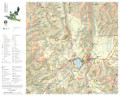
Map of the paths in the Colfiorito Regional Park
Tourist hiking map. A detailed 1:25.000 scale cartographic representation of the Park area. The official paths of the Park are marked in red and, on the back, there is an accurate description with the altimetry, photos and information
- Author/s: Regione Umbria
- Size: 21x13 cm
- Year: 2013
- Scale: 1:25000
- Price: free
Map of the paths in the Colfiorito Regional Park


© 2024 - Comune di Foligno