|
|
Parco del Delta del Po |
The Po river |
|
 |
The river Po is the the largest Italian river flowing into the Adriatic Sea and determinating the articulated territorial system of its delta. It begins from Monviso and winds for over 650 kms (it is not possible to precisely define its length, for the unceasable changes of the dimensions of the delta shaped by the river itself, by the sea, and by other natural and artificial agents). Recently, the Po delta branches out into five mouths: Po of the Maestra, Po of the Pila, Po of the Tolle, Po of the Gnocca, and Po of the Goro. It has not always been this way; on the contrary, as it happens when the water is one of the important elements of the morphology of a geographic region, the changeability of the places has been the main aspect of this landscape. In the last thousand years it has been radically transformed by the various factors (the quantitative dimension of the detritus, the climate, the eolian activity, the conditioning force expressed by the tributaries and by the sea, etc.). With time, the borders between the surface and submerged areas are slowly changing, the territory formed and has become relatively stable. In the Ferrara area and in the nearby Padana del Rodigino, towards the end of the Bronze Age, the river flow articulated into two main branches: the Po of Adria and The Po of Ferrara, which developed in many branches in the eastern area. The progressive contribution of the material along the marshy plain progressively pushed the coastal line towards the East, creating many dunes. |
|
|
|
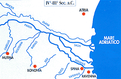 |
In the centuries significant hydrographic variations redimensionated the amount of water of the Po of Adria, a part in which entered into the Po of Ferrara thanks to a new course, the Poazzo. Along with the places where the Este city rose, the river divided into the Olana towards North ( its branches form a delta point in the Mesolano, to Monticelli, to the mouth of Gaurus), and the Padoa ( the Padovetere , where Spina rose) towards South. This was the axis of the flowing system and installation of the Ferrara inhabitant , the population also used it for the inside navigation, with the government control since the Etruscan Period. Many linking canals were built by the commercial developing service of Spina (VI - 111 century B.C.) that granted them the movement from Bologna to the Veneto via water. In the high medieval the delta form began to increase with major force of the Olana -Volano, mostly thanks to the mouth activity of the Gaurus, while the Padovetere lost progressively its efficiency, ( Branch between Voghenza and Ostellato). At the division between the two courses, at that time more important, the Volano and the Primaro, rose Ferrara. Around 1000 A.C. numerous accident phenomena were accumulated that affected the form of the delta: by the land reclamations promoted by the Benedectines of Pomposa , the lowering of the ground caused by the water presence found underground, followed by a entering of salt water in the Padana marshes. |
|
|
|
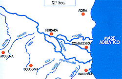 |
In the XII century, near Ficarolo ( upstream Ferrara, and on the left bank), The Po breaks its banks determining a decisive hydrographic variation for the territorial form in all the region of that time, in fact, the major part of the Padana water started to flow down the Po Grande river (it's still today the main branch of the river), and created the mouth at Fornaci, generating a new delta form. The Po of Goro strengthened and divided to flow with the mouth of Goro and in the south of Abate. In the following centuries the efficiency of the Ferrarese hydrographic system entered into a crisis:for the progressive covering of earth of the Po of Ferrara and the division of Volano R. and Primaro R. which followed disastrous floods and fulls worsened by bad attempts to meet one another the Appennine rivers like the Santerno and the Reno. |
|
|
|
 |
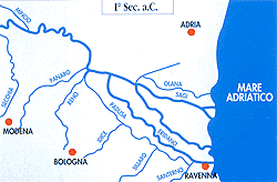
There was a multiplication of the salt water rivers that entered in the Low Ferrarese. The only obstacle opposed the many hydraulic disorders was the great Este land reclamation, that after twenty years had to surrender to the earth coverings.In the beginning of the 1600's the Taglio di Porto Viro (the Venetians, that obviated the danger of seeing themselves occluded by the Padana deposits the marshes mouths) barred the Po of Fornace and forced the great river to built a new delta, that progressive human interventions induced the development in front of the Ferrara coast.The territorial aspect that we see today is the gradual and still working evolution. |