


Protected Area
Identity Card
- Parco Locale del Monte Baldo Local Park:
- Land Surface Area: 4'650.00 ha
- Regions: Trentino Alto Adige - prov. TN
- Provinces: Trento
- Municipalities: Ala, Avio, Brentonico, Mori, Nago-Torbole
- Park Authority: Parco Naturale Locale del Monte Baldo
- Further managed Protected Areas:
- Riserva naturale provinciale Corna Piana
- Riserva naturale provinciale Lago di Loppio
- Zona Speciale di Conservazione Lago di Loppio
- Zona Speciale di Conservazione Manzano
- Zona Speciale di Conservazione Monte Baldo di Brentonico
- Zona Speciale di Conservazione Talpina-Brentonico
- Zona Speciale di Conservazione e Zona di Protezione Speciale Bocca d'Ardole - Corno della Paura
- Riserva naturale locale Fobbie - Laghetto della Polsa
- Riserva naturale locale Pasna
Monte Baldo Local Nature Park
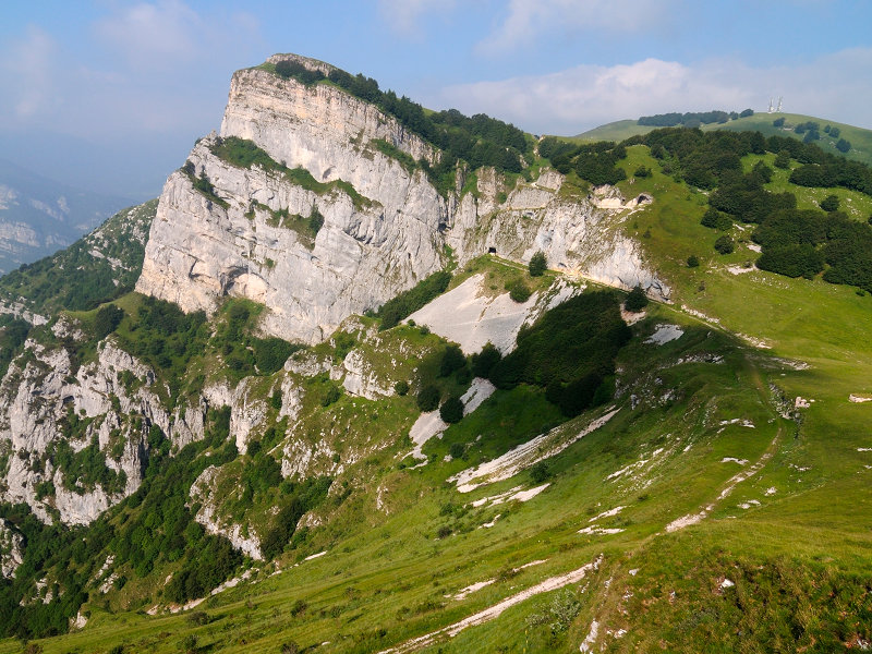
The Mount Baldo Local Nature Park extends over 4,650 hectares: from the Site of Community Importance of Manzano and Loppio Lake the northernmost strip of Mount Baldo, in the municipality of Mori, climbs the ridge and surrounds the Doss'Alto di Nago, the Mount Varagna, the Campei alpine meadow, the Campo alpine meadow and the Bes-Corna Piana provincial nature Reserve, up to the summit of the Altissimo Mount (a SCI of the Mount Baldo in Brentonico) in the municipalities of Nago and Brentonico. Then it climbs down again up to Bocca di Navene, the Aviana valley southwards. It climbs down along the Sorna valley up to Chizzola, and from the other side it covers the entire S. Valentino ridge, Corno della Paura, Bocca D'Ardole, Colme della Polsa, Colme del Vignola, Castel Saiori up to the SCI of Talpina.
The Park's total extent includes both the protected areas and the territorial environments for the ecological integration of the sites and the nature reserves or ecological corridors (1,898 hectares). The distribution in the different municipalities is the following: Brentonico (2,980 hectares), Mori (935 hectares), Nago-Torbole (640 hectares), Avio (75 hectares), Ala (21 hectares).
The basic idea of the local nature Park's establishment is to safeguard Baldo's habitats and species in a perspective of sustainable development, meaning by that a balance of the environmental, economic and social elements, as well as a long-term guarantee of such balance. This means that the Park is the expression of a proper territorial management, which recognizes the protected areas and the ecological corridors - considered as a unique whole - as the main elements.
(The following links lead to italian texts)

Story
The botanical peculiarities of Mount Baldo have been well known since 1400, when it started becoming the favorite headquarters for apothecaries, pharmacists and naturalists looking for species useful to treat some diseases. Thanks to its extraordinary biodiversity, Mount Baldo has been all along frequented also to carry out studies and researches on plants, flowers, minerals and rocks. During the second half of 1500 the famous apothecary Francesco Calzolari was the first one to praise the Mount Baldo.
Expert in recognizing and collecting medicinal plant species, he created an inventory of Mount Baldo's plant species (more than 350!), and he acknowledged that there was no other place in Italy with such a variety of plants. Therefore he exhibited samples of plants, animals, fossils found there in one of the first nature museums. At the end of 1500 the famous doctor from Cremona Giovan Battista Olivi, in order to highlight the particular biodiversity of the Park, called it "Hortus Italiae" (Italy's Garden).
Jean-François Séguier, in the first half of 1700, described it as a "Rarorum plantarium hortus" (A garden of rare plants).
In 1969 Luigi Ottaviani said that the story of Mount Baldo intertwines with that of the botanical nomenclature, and many plants are called with the qualifying adjective "baldensis". An example is represented by the Brassica baldensis, whose unique specimens were found and surveyed for the first time in 2007 by the botanists Alessio Bertolli and Filippo Prosser from the Rovereto City Museum. In 1971 the Italian Society of Botanics includes Mount Baldo among the areas of the "Survey of the biotopes of significant vegetational interest worthy of conservation in Italy", thanks to the richness in "endemic, rare or occasional species". From the survey it emerges the need of the establishment of an "interregional Park for the safeguard of both flora and fauna". In 1987 the Provincial City Plan identifies this area as one worthy of protection. In 2006, after the municipal council of Brentonico approved the document presented by the mayor Giorgio Dossi entitled "Brentonico Domani: linee generali per una crescita equilibrata dell'Altopiano di Brentonico" (Brentonico tomorrow: general guidelines for a balanced growth of the Brentonico upland), the key project for the territory's development was identified in the Baldo Park. From then on a real and systematic procedure was started in order to establish the local nature Park. In 2008 the president of the autonomous province of Trento Lorenzo Dellai and the mayor Dossi signed a "Program Agreement" for the establishment of the Brentonico's Reserves Network. In 2010 the Brentonico's municipal council together with the Trento's provincial council approved the Plan for the Management of the Brentonico's Reserves Network. Then also the governments and citizens of the municipalities of Ala, Avio, Mori, Nago-Torbole, of the Communities of the Alto Garda and Ledro and of Vallagarina were involved.
On the 14th of June 2014, at the Eccheli Baisi Palace in Brentonico, the Agreement for the establishment of the Mount Baldo Local Nature Park was signed by the President of the Autonomous Province of Trento, the Presidents of the Communities of Alto Garda and Ledro, of the Vallagarina and by the mayors of Ala, Avio, Brentonico, Mori, Nago- Torbole: the Mount Baldo Local Nature Park was officially established.
Biodiversity
If plant biodiversity has been well known long since, it is necessary to highlight that the Monte Baldo Local Nature Park is proud of several nature features, as it is reported in the Management Plan of the Mount Baldo's Reserves Network (January 2013), that is the technical-scientific document of reference for the management of the Reserves Network. The above mentioned features are:
- the presence of 20 different habitats of community interest (corresponding to the 60% of Trentino's 57 habitats of community interest), 8 of which have a particular value from the safeguard point of view, since they have been classified as priority habitats for the particular protection they need (corresponding to the 53% of Trentino's 15 priority habitats of community interest),
- the presence of:
- 1,655 plant species (corresponding to the 70% of Trentino's 2,359 vascular plant species),
- 9 species of amphibians (corresponding to the 69% of Trentino's 13 amphibian species)
- 8 species of reptilians (corresponding to the 73% of Trentino's 11 reptilian species)
- 117 bird species (excluding those which are present only during the migration) (corresponding to the 75% of Trentino's 156 bird species which are present during the mating period),
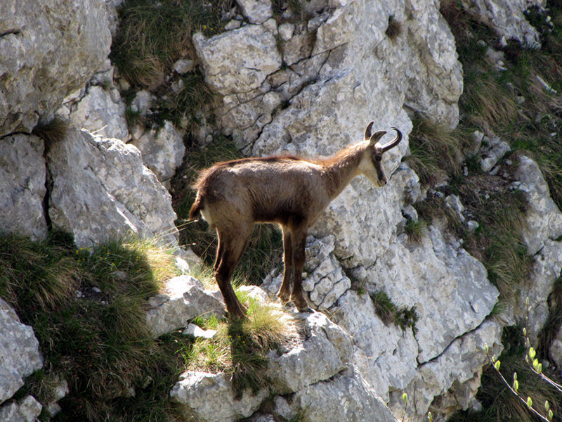
- 42 mammal species (corresponding to the 55% of Trentino's 76 mammal species).
The high level of biodiversity characterizing the local nature Park - showing itself in the above mentioned variety of habitats, animal and plant species - combines with a remarkable physical representation: the Park actually consists of a wide range of protected areas covering a large territory, from few meters above sea level up to the summit ridge of Mount Baldo, at an altitude of more than 2,100 meters.
Territory
Climate notes
Mount Baldo's climate is temperate, anyways there are considerable differences between the high-altitude areas - with the typical high-mountain conditions (freezing temperatures in winter and mild ones in summer, high annual temperature range and heavy snowfalls) - and the areas surrounding the Garda lake, characterized by a submediterranean climate. Garda's influence is anyways marked even on the summits: the heat stored by its waters is released and pushed up high at high altitudes by the wind streams, so that the Baldo's climate is mitigated. Furthermore, the area is less rainy than the surrounding pre alpine areas: this can happen thanks to the fact that Mount Baldo's north-west orientation channels the wet airstreams coming from the Po valley northwards, making them slide along its slopes.
Geological outlines
The sequence of Rocks on Mount Baldo, with the oldest outcrops at the foot and the newest ones on the summit, starts with the main Dolostone (200 million years ago, Late Triassic).
It developed in a not very deep marine environment with cyclical variations of the sea level, it mainly consists of layers made of dolostone and dolomite limestone, and it emerges at the base of the rock faces along the Vallagarina, between Chizzola and Avio, in the Loppio Valley, and at the core of Baldo's anticline.
With the low sea level conditions similar to the past, in the so-called "Piattaforma di Trento" (Trento's Platform), namely the wide carbonate sedimentation area which characterized the southern Trentino, it develops the group known as "Calcari Grigi di Noriglio" (Grey Limestones of Noriglio), north of Mount Varagna, in the locality of Bordina, in the lower Loppio Valley, in the areas of Manzano, Nomesino, along the whole right zone of Adige from Mori to Avio and on Mount Baldo's anticline.
Then there are the San Vigilio Oolite limestones, rich in fossil fauna, which developed until the end of the early Jurassic in a not very deep marine environment. The outcrops are situated along the Mount Baldo's ridge, in the eastern side of the Garda Lake, on Mount Giovo, in the village of Saccone, on Mount Vignola and in the locality of Talpina di Mori.
After a deepening of the sea bottom and a slowing down of the sedimentation process, hard-ground outcrops developed, together with fossil Foraminifera beside the Ammonites, which were already present in the most ancient substrata. Such typical features show themselves not only in the last Oolite layers in San Vigilio, but also in a later formation called "Rosso Ammonitico Veronese", emerging on Mount Giovo and in the locality of Colme di Vignola. The deep sea bottom (135 million years ago) gives rise to the formations of the so-called "Biancone", "Scaglia variegata" and "Scaglia Rossa", which are thickly stratified with flint elements and fossils, and they emerge in the locality of Corno della Paura, Colme di Vignola, San Valentino, San Giacomo, Castione, Saccone, Crosano, Prà da Stua and Valle di Gresta.
The collision compression stage between the African plate and the European one started in the Late Cretaceous (90 million years ago). The consequence of such phenomenon is the closing of the Tethys Ocean - the sea which extended over an area today occupied by Italy, Asia Minor, India, China, Japan - and the formation of the Alps.
In the early Cenozoic (65 million years ago) the sea bottom consists of several structures: some deep sea areas alternate with shallow sea areas and faults. In this context several formations developed: the sedimentation of the limestones in Torbole and, in the deepest sea areas, of Chiusole and Malcesine limestone, and the Formazione di Acquenere. Such outcrops typically emerged in the Gresta Valley, Prà Alpesina, Corna Piana, Colme di Bes, Crosano, S. Giacomo, Prada, Malga Campo and north of Brentonico.
During the Eocene (about 40 million years ago) both tuff and lava sedimented, proof of an intensive eruptive activity, which can be found in S. Valentino, Dossioli, Sorne, Crosano, Besagno, Castione, Valle San Felice, Pannone, Manzano and Nomesino.
At the end of this eruptive phase another marl limestone sedimentation occurred, which led to the formation of the Nago Limestones emerging in Colme die Bes, Corna Piana and north of Brentonico.
The collision between the European plate and the African one went on, and it culminated about 15 million years ago with the lifting, due to compression, of the Dolomites and the Prealps.
Then the erosion phenomena started because of the glaciers which developed in the Ice Age (15,000 years ago), the phenomena of surface alterations of freezing and thawing, the passing of streams and rivers, and karst phenomena which still occur.
The ecological corridors
The Provincial Law 11/2007 provides the identification of connecting areas among the protected areas, in order to guarantee a mutual connection. The ecological corridor's function is to allow the migration of the species from an area to the other, fostering that genetic exchange representing the base of the species conservation principle and of biodiversity. The ecological corridors can also represent areas of high landscape value.
The ecological corridors of Mount Baldo's reserves network are the following:
- The Sorna stream valley connecting Mount Baldo - Corna Piana and Talpina
- The ridge Passo di S. Valentino - Colme di Pravecchio - Corno della Paura - Monte Vignola - Dosso Rotondo, connecting Mount Baldo - Corna Piana, Bocca d'Ardole - Corno della Paura and Talpina
- The ecological corridor connecting Bocca d'Ardole - Corno della Paura and the small lake of Polsa, and between the small lake of Polsa and the ecological corridor of the Sorna stream
- The woody slope which from the northern boundaries of Mount Baldo di Brentonico's area climbs down towards Doss'Alto di Nago and the underlying Dossi della Barchessa, until it joins the Loppio Lake site.


