


Prati di Sara
- Trail Conditions: On foot
- Interest: Panorama, Hystory
- Departure: Casalino (940m)
- Arrival: Casalino (940m)
- Duration: 6 hour/s
- Difficulty Level: E - Hiking (level)
- Difference in height: 950m
- Maximum Altitude: 1,775m
- Recommended Period: from June to November
- Localities Crossed: Casalino - Passo Cisa - M. Bagioletto - Prati di Sara - Miniere - Casalino
The itinerary leaves with a historical route recovered thanks to an initiative of the National Park, then it continues on the traces of the linesmen who used to watch over the important power lines for Florence, across the beech tree wood and along isolated valleys. A completely different landscape awaits you in the plateau of Mt. Bagioletto and Prati di Sara, scattered with seasonal small lakes where you can enjoy a great view. The need for metal processing led to the opening of new mines in the dukedoms of Este between the 16th and 18th century. The mines above Casalino had short life: only a few traces of them are left on the spectacular Ciglio degli Schiocchi.
Further information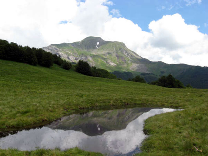
Prati di Sara with Mt. Cusna
 Download KMZ
Books and Guides
Price: 18.00 €
Price: 15.00 €
Item temporarily sold out at Emporio dei Parchi
Item temporarily sold out at Emporio dei Parchi

Protected Area(26.149,00 ha)

Lay-out of the itinerary

Departure - Arrival

Park Authority Offices (2)

Visitor Centers (9)

Where to Sleep* (3)

Where to Eat* (1)

Mountain huts/bivouacs* (4)

Nature Tour Guides (12)

Municipalities (13)

Points of Interest (148)

Photos (28)

Videos (6)

EV charge ≥100kW (286)

Airports (4)

Ports (1)

Station (6)

Highway exits (7)
*: only Operators with Accommodation Page


© 2024 - Ente Parco Nazionale Appennino Tosco-Emiliano