


Poiano and Sologno
- Trail Conditions: On foot
- Interest: Geology, Panorama, Hystory
- Departure: Fonti di Poiano (410m)
- Arrival: Fonti di Poiano (410m)
- Duration: 4 hour/s
- Difficulty Level: T - Tourist (level)
- Difference in height: 440m
- Maximum Altitude: 804m
- Recommended Period: from March to May, from September to November
- Localities Crossed: Fonti di Poiano - Poiano - Sologno - Ca' Rabacchi - Fonti di Poiano
The big dolines, the centuries-old chestnut groves, the remains of the lime kilns, the entrances of the caves crossed by subterranean streams, and the exit of the water in big resurgence springs: all the features of the karst system in the Triassic gypsum formations are concentrated in this itinerary. Moreover, Sologno is a town of great historical and environmental interest. The tour ends on a track running along the riverbed: this track has been asphalted after discussing it for a long time, and completed with didactic stops and naturalistic supports.
Further information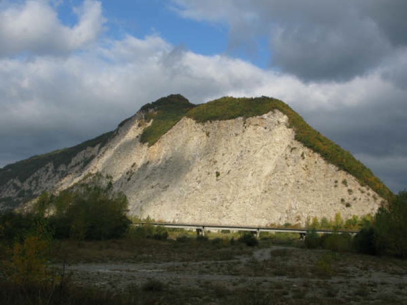
Mt. Rosso from Cà Rabacchi
 Download KMZ
Books and Guides
Price: 12.00 €
Price: 18.00 €

Protected Area(26.149,00 ha)

Lay-out of the itinerary

Departure - Arrival

Park Authority Offices (2)

Visitor Centers (9)

Where to Sleep* (3)

Where to Eat* (1)

Mountain huts/bivouacs* (4)

Nature Tour Guides (12)

Municipalities (13)

Points of Interest (148)

Photos (28)

Videos (6)

EV charge ≥100kW (286)

Airports (4)

Ports (1)

Station (6)

Highway exits (7)
*: only Operators with Accommodation Page


© 2024 - Ente Parco Nazionale Appennino Tosco-Emiliano