


Parco Nazionale Arcipelago Toscano - 2 Maps Scale: 1:25.000 / 1:15.000
Isola d'Elba - Capraia - Giannutri - Giglio Gorgona - Montecristo - Pianosa
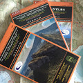
2 maps printed front and back on polyart®, hardback cover.
The maps show all the Park's official paths, points of interest, protected areas on land and at sea, practical information. One map (scale 1:25.000, front and back) is for the Elba Island, the other (scale 1:15.000) is for the other islands. The Elba map has a section on mountain bike (Capoliveri Bike Park) and shows the official tracks with their technical info (length, difference in elevation, slopes, level of difficulty). Overall, the maps show 435 km of paths, 684 km of dirt roads and 440 km of tarmac roads.
- Publisher: 4Land
- ISBN: 9788889823637
- Size: 12,5x23,5 (folded)
- Year: 2017
- Scale: 1:25.000 / 1:15.000
- Price: 14.95 €
Parco Nazionale Arcipelago Toscano - 2 Maps Scale: 1:25.000 / 1:15.000


© 2024 - Ente Parco Nazionale Arcipelago Toscano