


Alta Via No. 1
The most classic among the dolomitic itineraries
- Trail Conditions: On foot
- Interest: Flora, Wildlife, Geology, Panorama, Hystory
- Departure: Passo Duran (1,601m)
- Arrival: Belluno (389m)
- Duration: Itinerary in 4 stages: Day 1: 4 and a half hours. Day 2: 3 hours. Day 3: 4 hours. Day 4: 6 hours up to Bolzano Bellunese (7 hours up to Belluno)
- Difficulty Level: Day 1: E; day 2: EE; day 3-4: EEA. IMPORTANT: IN THE LAST TWO STAGES THERE ARE EXTREMELY DIFFICULT EQUIPPED ROUTES, WITH EXPOSED PASSAGES WHICH NEED A SUITABLE EQUIPMENT, TECHNICAL AND PSYCHOPHYSICAL TRAINING
- Difference in height: Day 1: 450 m uphill, 130 m downhill. Day 2: 540 m uphill, 760 m downhill. Day 3: 830 m uphill; 195 m downhill. Day 4: 100 m uphill; 1900 m downhill
- Recommended Period: from June to September
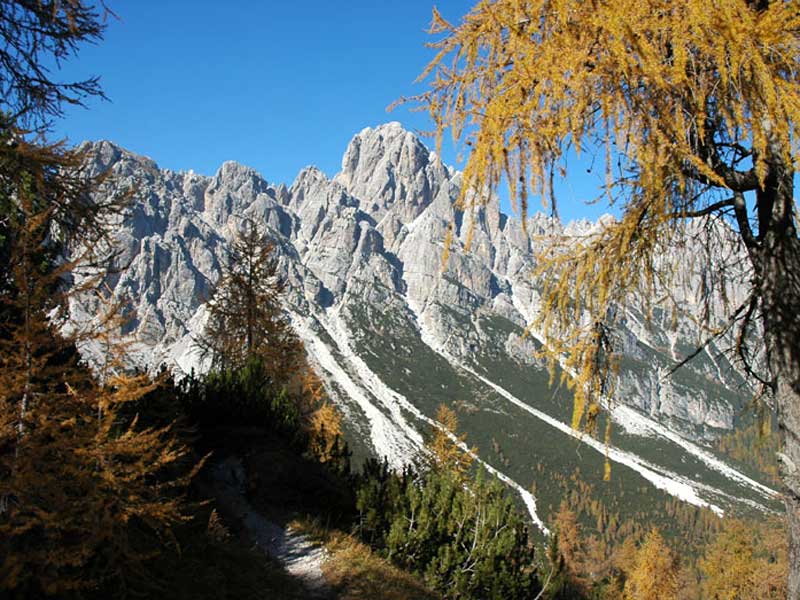
The Alta Via n. 1 is one of the classic great Dolomite crossings. Designed by Piero Rossi (one of the founding fathers of the National Park) in 1969, it starts from Lake Braies and ends in Belluno. It is divided into 12 stages, for a total of 125 kilometers in length, which exceed 7,300 meters in altitude uphill and 8,400 downhill. The park is affected by the last 4 stages, those which are generally less frequented, which, however, allow you to discover corners of the Dolomites that are still little known to the general public. Having 4 days it is possible to cross the eastern part of the park, from the Duran pass to Belluno.
Stage 1 from Duran pass to the Pramperet refuge
Leaving the Duran pass road, take the CAI 543 path, which climbs through the woods to the Dagarei fork (1,620 m). From here you walk along the western side of the Moschesin Castle to the Moschesin hut. Once past the hut, climb to Moschesin fork (where the ruins of the fort of the same name are located) and enter the territory of the National Park. From the fort you always descend along the CAI 543 path and, bypassing the Cime de le Balanzole, you arrive at the Sommariva al Pramperet refuge (1,857 m).
Stage 2 from the Pramperet refuge to the Pian de Fontana refuge
After leaving the refuge, take the CAI 543 path and climb up to the Portela del Piazedel (1,097 m). Through a spectacular high altitude environment you reach the Van de Zità Sud fork (2,395). This is the highest point that can be reached in the park with hiking trails. From here the gaze embraces the splendid glacial circuses of the Van de Zità (de Entro and de Fora) separated by the top of Le Preson (the prisons) which owes its name to the presence of cavities reminiscent of cells. The path 543 goes along the Van de Zità de Fora and descends to the Pian de Fontana refuge (1,632 m).
Stage 3 from the Pian de Fontana refuge to the Marmol bivouac
From the refuge, take the CAI path 514 to the junction with the path 520 that goes up from the Val dei Ross. Continue along path 514 going up to La Varetta fork (1,704 m), from here continue southwards until you reach the junction with path 518 that descends to the Bianchet refuge. Keep on path 514, pass the Casonet de Nerville and climb towards the homonymous fork, which you leave out to reach the Marmol fork (2,262 m). A frozen gully descends from the fork, as inviting as it is dangerous, which must be absolutely avoided, climbing to the right through rocks. You pass a ledge and some chimneys and you reach the crossroads that indicates the climb to the top of the Schiara. From the crossroads go down to the bivouac of Màrmol "Sandro Bocco" (2,266 m), where you will spend the night.
Stage 4: from the Marmol bivouac to Belluno
From the Marmol bivouac you descend along the via ferrata named after Piero Rossi (ex del Màrmol). The equipped route connects it with that of the Zacchi ferrata, ending next to the characteristic rock formation of Porton, from where you reach the 7th Alpine refuge. The descent from the bivouac to the refuge takes about 3 hours.
From the 7th Alpine refuge, the CAI 501 path descends the Ardo Valley to the town of Case Bortot. Here begins the paved road that leads to Bolzano Bellunese, from where it is possible to reach Belluno by public transport, thus avoiding a further stretch of about 4 kilometers on foot on the paved road.
 Download KMZ


