Protected Area
Identity Card
- Piana Crixia Regional Nature Park:
- Land Surface Area: 794.71 ha
- Lower altitude (m): 270
- Higher altitude (m): 631
- Regions: Liguria
- Provinces: Savona
- Municipalities: Piana Crixia
- Establishment Measures: L.R. n°8 27/02/1985
- PA Official List: EUAP0964
- Park Authority: Comune di Piana Crixia
- Further managed Protected Areas:
- ZSC Piana Crixia
The Park
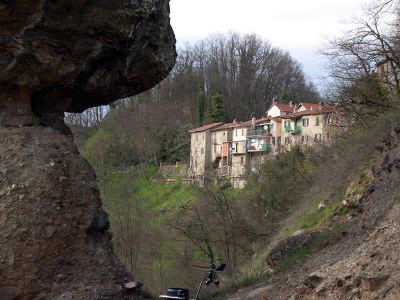
The Park, a watershed between the hills of the Langhe and the valleys created by the river Bormida and its affluents, extends itself within the territory of the town of Piana Crixia, a suggestive name deriving from an ancient Roman property. The landscape is characterized by the contrast between the plain areas, which have always been exploited by man for agricultural purposes, and the harshness of the overhanging mountains, in which the erosion by the atmospheric agents dug imposing gullies which are continuously evolving. A particular granite boulder set on a column formed by a clayey agglomerate, the so-called "Stone Mushroom" of 15 meters of height, is the most peculiar geological phenomenon of the territory and of the area of Liguria and Piedmont. The area is still characterized by a very rich fauna and flora.
The local population has preserved till present times the ancient traditions of working the products of the earth and of the wood, which are enhanced by a particular cuisine uniting the regions of Piedmont and Liguria.
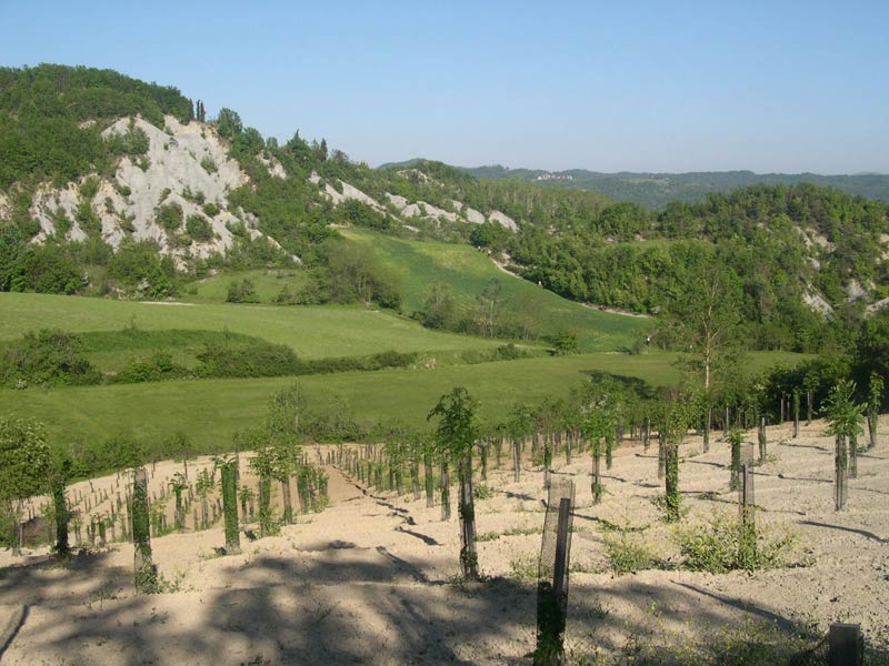
Gentle Cultivated Hills and Steep Slopes of Naked Rock
The hilly landscape of Piana Crixia, in the medium valley of the Bormida di Spigno, anticipates the features which can be found in the nearby Langhe of Piedmont. Gentle cultivated hills alternate with harsh mountains where the erosion revealed in many points the clayey substratum, shaping the characteristic gullies. The contrast between the grey color of the gullies and the colors of the surrounding fields and woods gives birth to a suggestive picture, unique in Liguria.
A part of this territory is situated in Piana Crixia Regional Park, extending itself for eight square kilometers on the left side of the valley of Rio della Madonna, at the border with Piedmont. In the park there is also a small isolated area near the country ward Borgo, where the famous "Mushroom" is situated, a spectacular rocky structure shaped by selective erosion.
The territory of Piana Crixia was inhabited by man since ancient times. As a matter of fact, important Roman and medieval ways of communication passed here. However, the hills mainly remained uninhabited until all the best grounds of the bottom of the valley were cultivated.
Within the protected area, only small agricultural nuclei developed above all since the 18th century, but the farmers always lived a difficult life because of the impending gully areas.
The Gullies and the Development of Vegetation
The gullies are characteristic forms of erosion of slopes made by clayey or marly sedimentary rocks which are impermeable and at the same time not very compact. Rain water flows on their surface, producing on the soft rock a marked erosive action. Consequently, the drills form and get gradually longer and branched, creating a net of small valleys with naked slopes separated one from the other by thin little ridges in rapid evolution.
The intense water flowing process prevents in the gullies the formation of humus and makes difficult the growth of vegetation. Some pioneer species, small herbaceous and particularly frugal plants are able to grow on the naked clayey slopes, but often to uproot them it is sufficient a downpour more violent than usual.
By observing the gullies of Piana Crixia it is possible to recognize the different development stages of the vegetation: where pioneer plants can resist, small quantities of humus accumulate and the first shrubs begin to grow; after their development, a soil stratum forms, and finally trees grow and consequently, a wood. However, it is a very slow process which in the gully areas is often interrupted by sudden landslides and must start each time from the beginning.
Enclosed Meanders and Suspended Valleys
The landscape of Piana Crixia Park is characterized not only by gullies, but also by a series of small rivers with an irregular course, with enclosed meanders and suspended valleys. This is given above all by the fact that the hydrographic network derives from a situation preceding the last geological events, and it has been partly influenced by recent fractures.
The enclosed meanders are bends which regularly come one after the other in a watercourse flowing in a narrow valley. In Piana Crixia you can observe the middle stretches of Rio Micheletto and Rio Rolando.
The several suspended valleys have been shaped by the considerable difference in erosion activity between the main and the secondary watercourses, marked by the scarce solidity of the clayey substratum.
A Fifteen-meter High Mushroom
Near the country hamlet Borgo, on the bank of a meander of the Bormida di Spigno, you can see the famous "Mushroom" of Piana Crixia, a unique form of erosion for Liguria and the surrounding areas. Similar forms can be found in some alpine areas, where erosion shaped ancient morainic or river-glacial deposits creating picturesque earth pyramids.