

Ancient road to Viù
First stretch: from Ponte del Diavolo to the Germagnano equipped area
- Trail Conditions: On foot
- Interest: Flora, Wildlife, Panorama, Hystory
The start of the path
The nature path linking the Ponte del Diavolo Reserve with the Germagnano equipped area is the first stretch of the hiking trail climbing the Viù Valley to reach the Resistenza Park in the Lis Hill.
From a strictly historical point of view the path represents the first direct way leading to the Lanzo Valleys. This way has been always used by the inhabitants of the valleys, but during the 16th and the 17th centuries it was improved thanks to the realization of a new mule track.
With two local ordinances approved by the "Credenza di Lanzo" (the current Municipal Council) on the 10th of January 1556 and on the 27th of April 1557 the mule track was demolished, and a fine of 100 "ducatoni" was established for the passage, because avoiding Lanzo people also avoided the duty.
The stretch was renovated only after the 15th of December 1621 thanks to the concession of the Marquis of Lanzo, Don Gismondo d'Este.
In one of his famous drawings dating back to 1840 Clemente Rovere represents the old Viù road in its best conditions but at the foot of the Basso Mount completely deprived of its trees, which were used to produce the coal for the many forges within the lower valley.
In the late 19th century it lost its importance and was abandoned in the 20th century because of the new road built at the valley bottom.
Itinerary from Lanzo
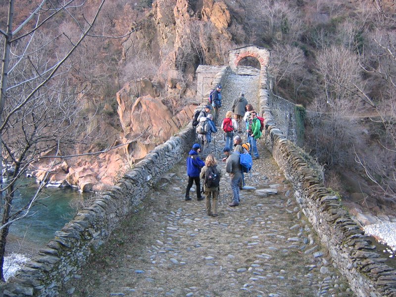
After reaching Ponte del Diavolo through the paved and then pebble road, cross it and turn right towards the mountain, walking alongside the river near the rocks, then climb a well visible path.
The path climbs on the Basso Mount's slopes up to the area about 100 meter far from the stream. Following the path alongside typical dry stone walls, after 15 minutes you will reach a panoramic point above the exit of the gallery leading to the three valleys: from here you can admire the Germagnano hollow which was once occupied by a large lake and then filled up with sand and gravel coming from the river. After the panoramic point the path goes uphill and reaches a ruin, then it goes downhill through a dirt road leading to the mountain huts of Basso Mount.
After the dirt road, near the two houses still in good conditions, take the path going down at the same level of the river first, and then go on crossing chestnut forests, oak trees and beeches. In the exposed gravel bed of the river you can see the grey herons living in the Stura all the year round. Along the way you can admire all the typical flowers of the undergrowth and mushrooms as well, but only during the periods established by mother Nature. The path goes on following the small valleys rich in vegetation and offering a shelter for the roe deers you can admire halfway in the nature trail.
The trail slowly goes out of the forest and offers you wonderful sights of the Germagnano's built-up area, where it is possible to see foxes too.
After reaching the ruins the path goes uphill on the left to reach the water collection point of an aqueduct, where a dirt road starts and leads to the Germagnano equipped area.


