|
|
Riserva Naturale Zompo Lo Schioppo |
Points of Interest |
|
|
|
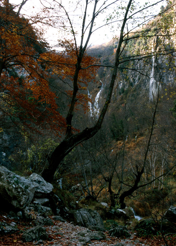 |
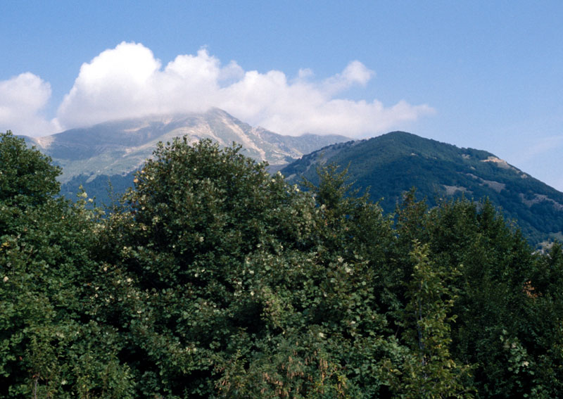
Zompo lo Schioppo is an example of intermittent karst source dying out every year in summer and autumn. The water spurts from a steep calcareous wall with a jump of more than 80 meters, forming the highest natural waterfall of the Apennine. The link between the landscape of the Reserve and the water element is so evident that it influences both its aspect and the ecosystem. The charm deriving from this combination of elements was noticed in the past by visitors, among the others Alexandre Dumas, who praised it in their travel diaries. The beechwood works as a "protection" on this system, and it forms together with it a landscape unity representing the image of the Reserve. The water can be found everywhere in the Reserve, from the highest sources situated at 1700 meters to the towns at lower altitudes. However, this presence represents only an aspect of its course: as a matter of fact, a concealed subterranean branching hydrography linked to the widespread karst phenomena develops in caves, karst valleys, wells and dolines, among the fissured limestone forming most of the backbone of these mountains and flowing out in some cases in bountiful sources like the one of Pantaneccia, which meets the water needs of Valle Roveto. Then comes the man, who shaped the hydrographic net with artificial courses and canals of various dimensions to exploit the potentialities of water. The technical ability with which men in the past were able to canalize the waters for irrigation purposes or to set the machinery going is well-known. This tradition, particularly alive among the Cistercian monks, still survives thanks to the so-called "formelle", that is earth canals irrigating the cultivated fields, which are the evidence of a reasonable exploitation of the territory. Of greater impact is the big artificial canal built by Enel, which makes the waters of the stream Lo Schioppo flow into a "loading" lake to move in the end, through a pressure water pipe, the turbines of one of the power stations in the territory of Morino. |
Grancia |
|
 |
The location Grancia in the Municipality of Morino, where there are the seats of the Reserve's headquarters and the museum, is an important settlement witnessing the historical events of the territory of the Reserve. The name, rather common in the Italian toponymy in this form or as "granza" or "grangia", derives from the French word "granche" or "grange", which in turn derives from the Latin "granica" (= place used as a wheat deposit). In the Middle Ages, this word was used to identify particular structures connected to the monastic settlements; it could both refer to a building used as a deposit for agricultural products situated within an abbey complex and to an autonomous group of buildings far from the abbey, but linked to the exploitation of the local resources owned by the monastery. In the last case, the "grancie" were farmsteads basing their economy not only on the cultivated fields, the pastures for the flocks, the forests providing timber, but also on the exploitation of the local quarries and mines, with buildings functional to the use of these resources like mills and forges working thanks to a wise use of the power of water. This kind of agricultural settlement is mentioned in written documents dating back to the 12th century and it mainly depended on the monasteries of the Reformed Benedictine, the Cluniac, the Cistercian, and the Carthusian monks, famous for revolutionizing not only the religious spirituality of their period, but also for improving the exploitation of the estates they owned through a more dynamic economic management careful to the technical advances conquered by the agriculture of the Lower Middle Ages. Moreover, the technical skills with which, above all the Cistercian monks, canalized the waters for the drainage and the irrigation of the fields or for the exploitation of the water energy in the machinery employed in the raw material processing are well-known; this use is documented for instance in the French abbey of Fontenay, where the strength of the water moved the heavy power hammer of a forge used in metal working. The Cistercian "grancie" have been studied from an architectural point of view above all in England and in France while in the rest of Europe, including Italy, the researches are still far from a global vision of the phenomenon. However, in general, the architectural typology of these buildings varies a lot, and it remains strictly linked to the function they had: storehouses for cereal, cellars, barns, workshops, etc. |
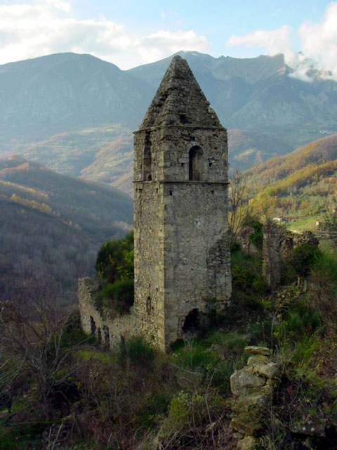
| The "grancia" of Morino, depending on the Cistercian abbey of Trisulti, is one of the most famous complexes of Abruzzo; it is characterized by the toponym Grancìa, by the existence of craftsmanship evidences, like the mill and the metal forge - the latter described by Alexandre Dumas around the half of the 19th century, and finally by the abundant presence of water, essential both for the agricultural exploitation of the soil and for the working of the craftsmanship plants. The ruins of the mill near the building housing the museum and of the ironworks structures which were situated not far away along the stream of the Schioppo lead to believe that the center of the "grancia" coincides with the area where the museum rises. The "grancia" of Morino is not the only interesting historical structure in the reserve: there are also some other important monuments witnessing the local historical events and settlements. The ruins of the ancient historical town center of Morino are picturesque, and they dominate from the summit the bottom of the valley. The settlement developed from the homonymous castle mentioned in the writings of the 12th century, which had been probably built on a "marso" fortified center. The old town was inhabited until 1915, when, because of the strong earthquake in Marsica, it was abandoned and then rebuilt in the current area. In the location Brecciose there are the ruins of the church of S.Pietro, known since the second half of the 11th century as a religious building depending on the Benedictine abbey of Montecassino. The most charming and best preserved monument, at least as far as the structure is concerned, is the church of S.Maria del Pertuso, also called del Cauto, situated at about 1000 mt. near the waterfall of the Schioppo. The building, which is mentioned in documents dating back to the 12th century, lies within the estate of the Cistercian abbey of Casamari. The not very big structure is partly carved in the rock, and it preserves some fragments of the frescoes decorating its vault and the walls with representations of the Madonna, the Saints, and the clergy. |
|
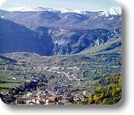
Morino |
|
|
A mountain municipality of medieval origins, it survived in the past almost exclusively thanks to the exploitation of the forests; nowadays the human activities have been absorbed by the industrial and trade centers of Avezzano Sora and of the area of Roma. The community of the Morinesi is characterized by an average rate of old age and is scattered among the settlements of Biancone and Fossa and in the towns of Morino, Grancia, Brecciose, and Rendinara. The administrative center, Morino, has recently formed, and its modern town planning clashes with the harmonious blend of the landscape and of historical-architectural values which were represented by the ancient settlement: of it today only ruins remain. The territory of the Municipality extends itself in the middle valley of the Liri; the harshness and the variety of its altimetric profile is emphasized near the Simbruini mountains housing the valley of the stream Lo Schioppo, protected by a Natural Reserve and enriched by a myriad of small waterfalls, by a luxuriant flora, and by rare animals like the Brown bear, the Apennine wolf, the Marten, etc. In the heart of the Reserve there is a wonderful little church, the Madonna del Cauto (Italian text), which was in the past a place of hermitage.
Further information (Italian text) |
Valle Rovereto |
|
From Prehistory to the end of the Roman periodThe geomorphological aspect of the territory, which lies mainly in a mountain area and is accessible through mountain passes, has influenced since ancient times the distribution and the density of the population, even if it has not prevented the passage and the contacts between the human groups since the Paleolithic Age. |
|
The Roman Age: the Municipium of Antinum and the villae systemDespite the lack of thorough archaeological surveys in the valley of Liri, except for the excavations carried out in 1990 in the ancient town hall of Antinum, the current Civita d'Antino, it is possible to define the landscape characterizing the territory already in the Roman period, starting from the data provided by the local archaeological finds and those inferred by the studies of ancient topography. |