|
|
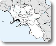
Sito di Importanza Comunitaria del Fiume Alento |
Protected Area |
||
 |
|
|
Protected Area SCI IT 8050012 - River Alento |
||
|
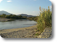
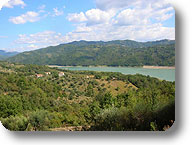
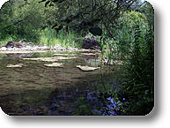
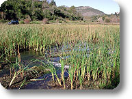
The area extends for 3,024 hectares and develops along the course of the river Alento and its tributaries. The river Alento springs from Mt. Le Corne (894 m. a.s.l.), less than one kilometer away from Stio, and then crosses, immediately after the spring, the small town of Gorga, always remaining within Cilento e Vallo di Diano National Park. The 36km long river leaves the Park territory after about a dozen of kilometers and goes back in it with the last 3 kilometers, flowing into the sea near Velia. The site also includes the final stretches of some of the tributaries of Alento, like Vallone Corbella, Vallone di Ostigliano, Fiumara della Selva dei Santi, Badolato, and Palistro. The area also includes the dam of Alento, which represents a water basin of strategic importance for the whole South. Moreover, the creation of the dam has led to the formation, downstream, of a system of wetlands consisting of seven small lakes with a great naturalistic value. |
|
The River Alento |
||
| The land of Cilento was named after the ancient Hales and the more recent Alentum. As a matter of fact, the term "Cilento" dates back to the Benedictine Monks who named this land Cis Alentum, meaning "on this side of Alento". The river has a torrential regime, with big flows in the rainy periods and more or less meagre flows in the dry periods. It springs from Mt. Le Corne (894 m a.s.l.), within Cilento e Vallo di Diano National Park, less than one kilometer away from the town center of Stio. Immediately after the spring, the river flows near the small town of Gorga, always within the National Park, in the Municipalities of Cicerale and Perito. In its first stretch, the course of the river follows a south-north direction, running parallel to the mountain chains. Further information (Italian text) |
||
Fauna |
||
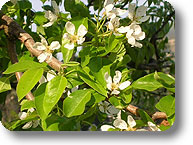
| Although it does not have a considerable size, the SCI river Alento includes different habitats: three forest formations, that is Mediterranean maquis, mixed wood of heliophilous broadleaf trees, gallery forest along the banks of the river; grasslands or steppe, wetlands covered with cane-brakes, areas cultivated with vineyards, olive trees, and other fruit plants. This diversity of habitats reflects in a great variety of animal species that find here the ideal place to spend their whole life or just a period of it. The SCI river Alento is characterized by a very rich fauna for the number of species, some of which have a great conservation value to the extent that they have been inserted in the annexes II and IV of the Habitat Directive, and therefore need a special protection. (the following links all lead to Italian texts) |
||
Vegetation and Flora |
||
|
The landscape of the watercourse of Alento has the same features of the rest of the territory of Cilento. Along the upper watercourse, the cultivated fields alternate with large pastures. In these areas, the dominating species are the Olive Tree (Olea europaea), the Fig (Ficus carica) and the Grape (Vitis vinifera), while the typical vegetational association of the area is the Mediterranean maquis, consisting of the "Lauretum" up to 250 meters asl and the "Castanetum" in the upper areas. The "Lauretum" consists of Tree Heath (Erica arborea) associated with Holm Oak (Quercus ilex), Lentisc (Pistacia lentiscus), Bilberry (Vaccinium myrtillus), Olive (Olea europaea) and, along the banks of the river, White Willow (Salix alba). In the "Castanetum" it is possible to find the Downy Oak (Quercus pubescens), the Turkey Oak (Quercus cerris), and the Italian Alder (Alnus cordata). It is also possible to meet Ampelodesmos mauritanica, shrub formations with Spanish broom (Spartium junceum) and Phyllirea latifolia. Near the thalweg, there are also canebrakes consisting of Arando pliniana. The medium and lower course of the river is partly cultivated with vineyards, olive groves and scattered fig plants combined with large areas of Mediterranean maquis and, along the lower course, orchards have been recently planted. The stretch of the dam in Omignano is characterized by a plain forest vegetation mainly consisting of plants typical of the riparian vegetation. It is also possible to find Crack Willows (Salix purpurea), Riparian Willows (Salice eleagnos), Black Poplars (Populus nigra) and isolated nuclei of White Poplars (Populus alba) and, in the back lands, Inula viscosa, Curry Plant (Helichrysum italicum), Common Broom (Spartium jumceum). Near the lateral basins you can find the Common Cattail (Typha latifolia). |
|
Geology and Land Morphology |
||
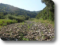 |
Geology In Cilento there are two important geological formations. The ideal line of demarcation between the two formations runs from north to south, from the town of Capaccio to Sapri. In the east of this line, towards the inland, there are the calcareous chains of Alburni, Mt. Cocuzzo, Cerasulo, Motola, and Cervati (1,899 m a.s.l.); in the west, towards the sea, the flysch of Mt. Stella (1,130 m a.s.l.), the Sacro or Gelbison (1,705 m a.s.l.) and Centaurino (1,433m a.s.l.). Fluvial Morphology Further information (Italian text) |