

Protected Area
Identity Card
- Serre Regional Nature Park:
- Land Surface Area: 17'687.00 ha
- Regions: Calabria
- Provinces: Catanzaro, Reggio Calabria, Vibo Valentia
- Municipalities: Acquaro, Arena, Badolato, Bivongi, Brognaturo, Cardinale, Davoli, Fabrizia, Francavilla Angitola, Gerocarne, Guardavalle, Maierato, Mongiana, Monterosso Calabro, Nardodipace, Pizzo, Pizzoni, Polia, San Sostene, Santa Caterina dello Ionio, Satriano, Serra San Bruno, Simbario, Sorianello, Spadola, Stilo
- Establishment Measures: L.R. 10 14/07/2003 - In attuazione della L.R. 05/05/1990 n. 48, modificata ed integrata con la successiva L.R. 14/07/2003
- PA Official List: EUAP0660
- Park Authority: Ente Parco Naturale Regionale delle Serre
- Further managed Protected Areas:
- Zona Speciale di Conservazione Bosco di Stilo - Bosco Archiforo
- Zona Speciale di Conservazione Bosco Santa Maria
- Zona Speciale di Conservazione Lacina
- Zona Speciale di Conservazione Lago dell'Angitola
Serre Regional Park
The Serre represent a rather complex mountain chain of great natural-environmental value, connected in the south with the mountains of Aspromonte.
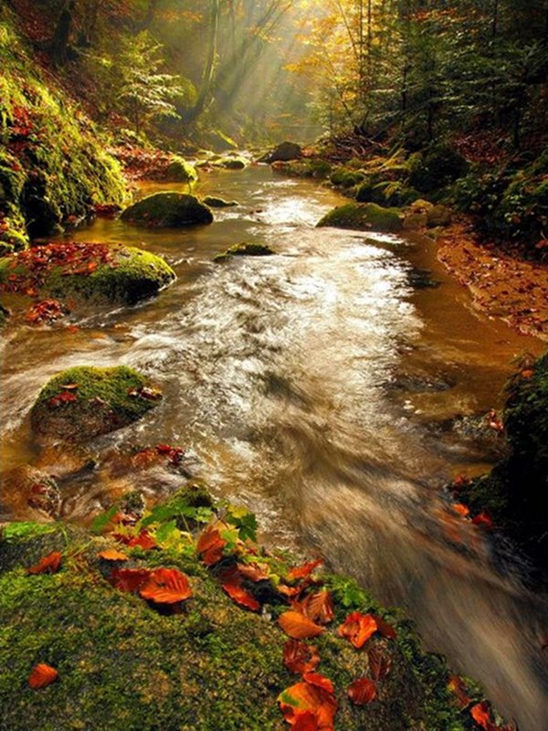
As far as geomorphology is concerned, there are two long and opposite mountain chains (Mt. Covello, Cucco and Mt. Pecoraro) running almost parallel along the Apennine chain. The mountain chains are partly divided by the upper valleys of Ancinale basins, the large valleys and the Stilato (on the border of which you will find the locality Ferdinandea, famous hunting reserve of the Bourbon Kings, around which there is the wood of Stilo, as well as the imposing waterfalls of Marmarico, which, with a difference in height of 90m, flow into Stilaro).
Beautiful waterfalls, even if smaller in size, enrich the Serre, giving birth to natural architectures of great charm: among the others the Pietra Cupa waterfall on the torrent Assi agro di Guardavalle, which, with a very fast slipway of over 15m runs along a smooth rocky wall surmounted by giant and twisted trees until a large lake surrounded by bushes and shrubs.
Not far from Ancinale, the river Alaca runs: it springs from the Lacina basin and develops along a long stretch at the bottom of a narrow woody valley enclosing wonderful architectures made of rocks and waters.
In the south between F.ra Precariti, forming a short but very spectacular canyon, and F.ra Amuse the other important watercourse of Serre runs, F.ra Allaro. However, it is F.ra Assi, situated almost in the middle of the Ionian side of Serre, which encloses and enhance the features of the lower and middle courses of the torrents.
The geological nature of Serre is mainly formed by crystals, with a very widespread presence of granites, porphyries, serpentines, quartziferous diorites, etc., which are well evident from the upper stretches to the final stretches of the watercourses.
Further geological features of Serre Park are the gullies, characterizing the slopes of the sub-mountainous strips above all in the north and in the east.
According to L.R. no. 48/90, the establishing aims of the Park are the safeguard of the natural and cultural environment, as well as the improvement of the life conditions of the local communities.

Main Features
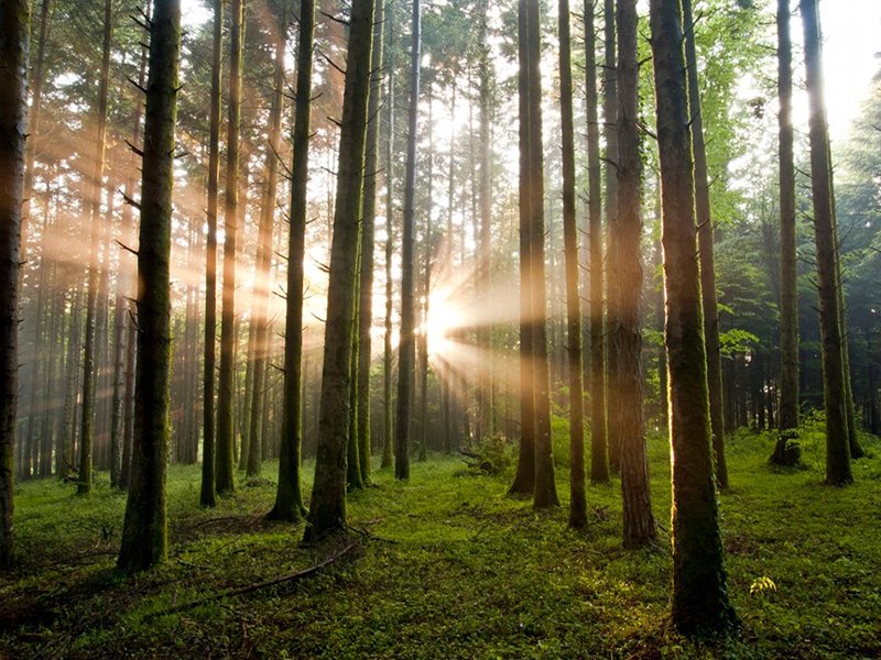
The Park area is characterized by the widespread presence of woodlands and forests, Mediterranean maquis, grazing lands, rural fields. There are very important places of worship (like the centuries-old Abbey of the Carthusian monks in Serra S. Bruno, one of the few which have remained active, the grave of St Bruno of Cologne, the founder of the Carthusian Order), the naturalistic-ecological itineraries, as well as the evidences of industrial archaeology dating back to the Bourbon period; finally, there are several springs, streams, and torrents.
There is a Mediterranean climate with mild winters and hot summers.
Flora and Vegetation
The dominating vegetable species are: Castanea sativa (Chestnut tree), dominated by high-trunk species in the best areas and by coppice in the others, Pinus nigra (Austrian Pine), Alnus glutinosa (European Alder), Alnus cordata (Italian Alder) in spontaneous high forests covering all the valleys, the coolest areas, and the river banks, Fagus selvatica (Beech tree) and Abies alba (Silver Fir - species of great naturalistic importance) present in groups and in pure and mixed woods, more or less extended in the highest and coldest areas, Quercus ilex (Ilex tree), Populus alba (White Poplar), Populus tremula (Common Maple) and Robinia pseudoacacia (Black Locust) occasionally in the lowest areas.
The shrub vegetation is rich and includes some of the most characteristic essences of the Mediterranean maquis: Broom, Heather, Strawberry tree, Myrtle, Phyllirea, Rock Rose, Mastic Tree, Holly, etc.
The natural surface of the soil of the Park territory is also interesting for the ecological and silvicultural features of the Silver Fir.

Fauna
The fauna populating the Serre mainly consists of wild boars, foxes, badgers, wild cats, weasels, and stone martens. Moreover, there is the very rare Corsican hare, which is a very interesting species from a scientific point of view. The birds are also present in rich groups. Among them, the Song Thrush, the Grey Heron, the Raven, the Woodcock, the Great Tit, the Hoopoe, the Magpie, the Gowshawk, the Sparrow Hawk, the Eagle Owl, the Peregrine, the Green Woodpecker, the Great Spotted Woodpecker, and also the rare Black Woodpecker. The most common fish species are the Eel, the Carp, and the Brown Trout.
| Mammals | |||
| Sus scrofa (Wild Boar) | Martes foina (Stone Marten) | Mustela putoriuas (Polecat) | Mustela nivalis (Weasel) |
| Meles meles (Badger) | Lepus capanesis (Hare) | Martes martes (Pine Marten) | Vulpes vulpes (Fox) |
| (Wild Cat) | |||
| Birds | |||
| Turdus philomelos (Song Thrush) | Falco vespertinus (Red-footed Falcon) | Ardea cinerea (Gray Heron) | Asio otus (Long-eared Owl) |
| Corvs Corax (Raven) | Scolopax rusticola (Woodcock) | Paros major (Great Tit) | Oriolus oriolus (Golen Oriole) |
| Turtus pilaris (Fieldfare) | Coturnix coturnix (Quail) | Phasianus colkicus (Common Pheasant) | Upupa epops (Hoopoe) |
| Pica pica (Magpie) | Carduelis carduelis (Goldfinch) | Erithacus rubecula (Robin) | Green Woodpecker, Great Spotted Woodpecker, etc. |
| Reptiles | ||||
| Vipera aspis (Asp Viper) | Lizard | Salamander | Rat Snake |
Toad |
Moreover, among the freshwater fauna we must mention the Brown Trout, the Eel, and the Carp, while among the entomological fauna there are several species of insects, lepidopterans, and coleoptera.

Zoning
Given the variety of the natural environments present in the Park area, as well as the presence of human settlements since ancient times, it wouldn't be reasonable to implement the same safeguard, conservation, and enhancement measures everywhere.
Therefore, the so-called "zoning" is used (division into zones of the Park territory) consisting in dividing the area into different zones, subject to different safeguard criteria according to the features of the vegetable and geomorphological formations and to the environmental features.
From the areas preserving the most intact and integral natural features, we can distinguish four zones (A-B-C-D) going from the strict nature reserve to the areas which are more linked to production activities and/or more used for different purposes (grazing lands, agricultural fields, arboriculture).
| Zone A (strict nature reserve) | Of great naturalistic value, the environment is here preserved in its integrity. It covers an area of 236 hectares, that is the 1,33% of the Park surface. It partly consists of the SCI "bosco Archiforo, bosco Santa Maria e Monte Pecoraro". |
| Zone B (reserve with particular purposes) | In this area, building activities are usually forbidden, except for the structures and infrastructures strictly linked to the traditional agricultural, silvicultural, and grazing activities typical of the area. It covers an area within the Park territory and includes regional forests and the outer strips adjacent to zone A. |
| Zone C (protection area) | The agricultural, silvicultural, and grazing activities, as well as craftsmanship activities and the collection of natural products can continue according to traditional uses or biological agriculture methods. It covers an area of 12.145 hectares, that is the 68,67% of the Park surface and includes the state municipal properties and/or other state properties, as well as the agricultural, silvicultural, and grazing private properties in general. |
| Zone D (development area) | It includes the urban centers, the periurban areas, the expansion areas and the adjacent areas, as well as tourist and production areas. Within it, the activities which are compatible with the establishment aims of the Park are allowed, as well as the activities aimed at the social-cultural improvement of the local population. Except the projects contained in the town planning instruments in force. It covers an area of 50 hectares, that is the 0,28% of the Park surface. Moreover, the management subject will establish the rules of use for each area. |
| Oasi (Lago) Angitola |
It includes the homonymous lake and the surrounding safeguarded areas. It covers an area of ha 875, that is the 4.95% of the Park surface. |


