

Protected Area
Identity Card
- Land Surface Area: 1'027.00 ha
- Regions: Toscana
- Provinces: Firenze
- Municipalities: Reggello
- Establishment Measures: DCC 72 28/07/2005
- Park Authority: Comune di Reggello
Balze del Valdarno
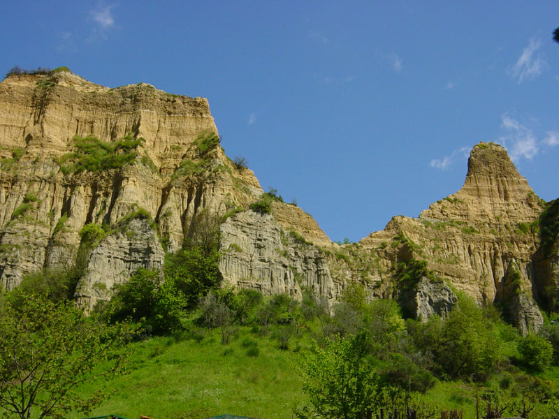
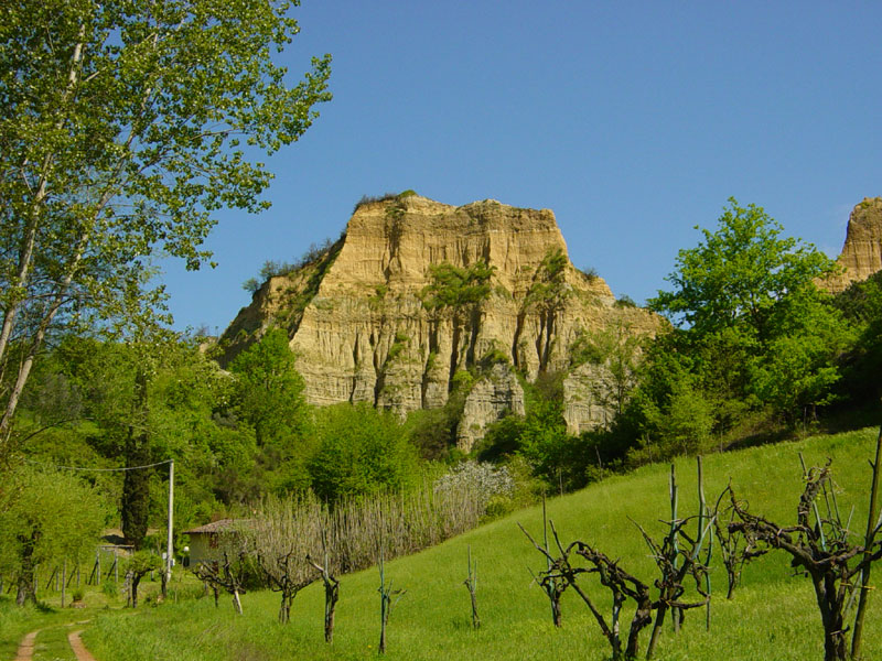
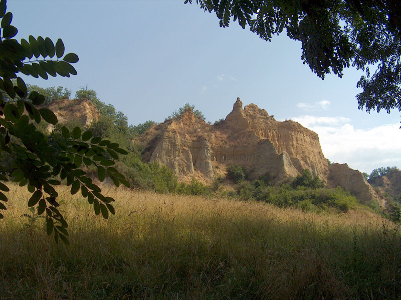
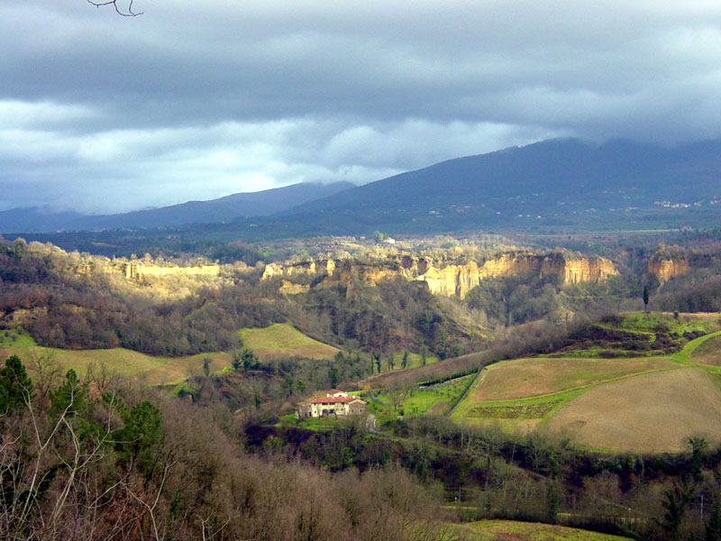
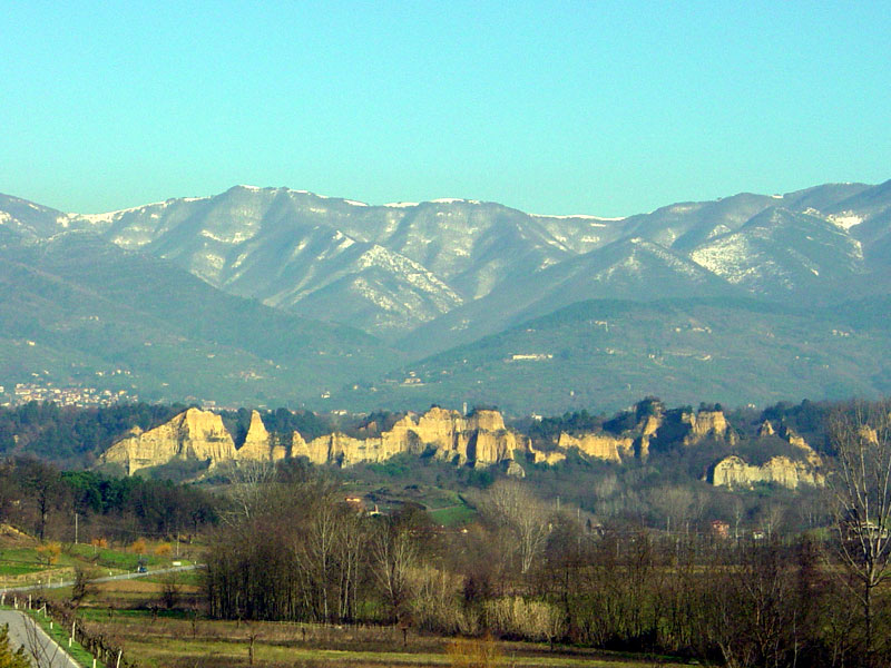
The stretch of territory called "Upper Valdarno", delimited by the right bank of the river Arno and by the hilly formations introducing Pratomagno, is characterized by geological structures of particular charm and beauty formed by stratified sand, clay, and gravel reaching one hundred meters of height and by a series of diversified shapes alternating with deep ravines. These structures, called Balze, are not only the result of the dismantlement of the ancient sediments by the atmospheric agents, but they have also been shaped by the presence of man.
In 1998 the Municipalities of Terranuova Bracciolini, Castelfranco di Sopra, Loro Ciuffenna, and Pian di Scò promoted the safeguard of the area establishing an ANPIL (which stands for "area naturale protetta di interesse locale", that is a protected area of local interest).
The section of the protected area in the Municipality of Reggello, province of Florence, aims at defending Le Balze from landscape damages in order to safeguard not only their environmental aspects, but also the cultural and landscape values of the area.
As far as tourism is concerned, the potentialities of the area - going from the Municipality of Reggello to the Municipality of Castiglion Fibocchi, along the road of Setteponti - are promising if we consider its size, richness in values, proximity to three cities of art like Florence, Siena, and Arezzo, which are tourist destinations par excellence, the presence of important ways of communication like Autostrada del Sole and Direttissima, the considerable presence of the more careful and aware foreign tourists.
Geography
Upper Valdarno is an intermountain basin between Florence and Arezzo,
one of the largest basins of the northern Apennines, delimited in the
west by Chianti Mountains (with a maximum height of 892m) and in the
east by Pratomagno chain (reaching the 1,591m).
Upper Valdarno is
characterized by several different landscapes like the plain, the
hills, the tablelands, and the mountain slopes belonging to the
Apennines.
The
annual average temperature of the valley bottom is 12,8°C, with the
highest temperatures recorded in August and the lowest in December. In
autumn and winter, fog or a slight mist tend to stagnate in the valley
bottom, with frequent frost. In winter, snow falls over the 1,000 m.
The administrative borders involve two Provinces: Florence and Arezzo,
with 14 Municipalities. However, the sharp and precise conformation of
Upper Valdarno also forms a geographical area known all over the Region.
The most common rocks are sandstones, sands, and clays. Valdarno is one
of the richest areas in fossils belonging to the big mammals of the
past. Moreover, it houses the largest xyloid/lignite basin of Italy.
It is crossed by important ways of communication: besides the SS road,
it is crossed by A1 Highway and by the expressway Rome-Milan.
The
Valley is also crossed by the middle stretch of the river Arno which,
together with its tributaries, eroded the debris filling the bottom of
the Pleistocene lake which one hundred thousand years ago accumulated
in a large area about 40 km long (from Laterina to Matassino) and 10 km
wide (from Chianti to Pratomagno), reaching the 300 m of height. This
tableland was completely eroded in the section of Chianti since, moving
the river Arno towards this side, the surface waters could entirely
tear down the stratum of lake sediments. On the contrary, the side of
Pratomagno was covered by a tableland of almost the whole size of the
mountain, where towns and country hamlets like Reggello, Pian di Sco,
Castelfranco, Persignano, Piantravigne, Montemarciano, Loro Ciuffenna,
San Giustino, and Laterina have been built.
The tableland is a few
hundred meters wide and 260-280 m high. It is suddenly interrupted by
vertical walls dozens of meters high bordering it at its foot like an
almost non-stop frame characterized by a typical yellow-ochre color.
The way Le Balze appear depends on the erosion of the washing-away
waters which, descending from the slope of Pratomagno before, and from
the tableland after, finally flow into the river Arno.
The road of Setteponti crosses the tableland and links Arezzo to
Fiesole. It is a very panoramic road giving the opportunity to enjoy
the view of the beautiful hills cultivated with vineyards and olive
trees and scattered with the characteristic farmhouses, many of which
are working Agricultural Farms or Holiday Farms. Many other roads
leading to Pratomagno leave from this main road.
Geological History
Italy as we see it today is the result of the slow but continuous clash
between the two "plates" into which the earth's crust is divided: the
African plate and the European plate. The folding of the Apennines,
which began about 25 million years ago, originated from this powerful
clash.
Once the pressure causing the compression of the rocky strata
ended after rising them from the bottom of the sea where they had
mainly formed and transforming them into high mountains, the Apennines
were interested by a sort of "relaxation" which originated a series of
grabens: Valdarno is one of the largest among these holes, including
also Mugello, Valdichiana, Casentino, and Valtiberina.
When at the
end of the Pliocene age the bottom of the current Valdarno slowly began
to sink, the surface waters could not flow out and, as a consequence,
accumulated, forming a lake which covered only the western part of the
basin first and, afterwards, the rest of the valley.
During the first lake stage the climate was similar to what we can find
today in the luxuriant tropical forests, as demonstrated by the fossils
of plants and animals on display in the Paleontological Museum in
Montevarchi.
It
is in the second lake stage of Valdarno basin, between two million and
one hundred thousand years ago, that the materials - mainly clay at
first, and sands and pebbles then - we can observe today in the walls
of Le Balze accumulated in the ancient lake or nearby, dragged by the
watercourses descending from Pratomagno.
During this stage, the
climate was less hot, tropical plants disappeared, and the animals of
the savannah arrived from eastern Europe: elephants, rhinos, hippos,
tigers, monkeys, and hyenas...
The
non-stop transport of sediments produced by the disintegration of rocks
caused by atmospheric agents from the highest areas to the lake
determined its progressive filling up, transforming it first in a large
pond with stretches of water which periodically dried up and then
filling it up completely. A large plain covering the whole basin
formed. The current area of Valdarno plateau is what remains today of
the old filling-up area.
Once the lake had dried up, an
hydrographic network formed, with a major watercourse running in the
middle of the plain and, parallelly, a series of affluents.
A new stage of the geological history of Valdarno begins: the erosive stage.
As
a matter of fact, downstream Incisa the soil lies at lower altitudes
with respect to Valdarno plain: the river Arno and its affluents begin
to dismantle the fluvial-lacustrine soils which had previously
accumulated.
The soils that had filled up the lake and formed a
large tableland are gradually engraved and dug and valleys and ravines
form. The course of the river Arno progressively lowers until it
reaches the current level, about 150 m lower than the filling-up
surface. Billions of tons of earth are continuously removed, the
erosive activity shapes the soil forming rounded hills near the clays
towards the middle of the basin and vertical walls - Le Balze - in the
soils which are more resistant to erosion.
Therefore, when we
observe a wall of Le Balze, we are not merely looking at a heap of
still earth, but also at a cross section of natural history of great
value, a survivor of primordial strengths and catastrophic events, an
evidence of the millenary struggle of nature looking for its balance.
The
withdrawal of the front of Le Balze is given to the drainage ditch
waters and to the washing out waters along the walls undermining them
at the base and causing their collapse under the weight of the
overhanging conglomerate stratum which is no longer supported.
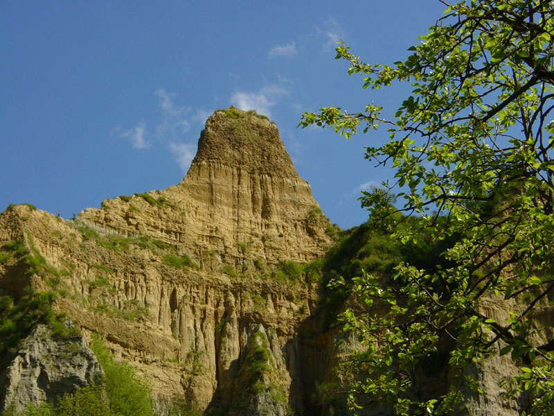
As
far as the erosion continues, the walls are gradually dismembered in
isolated shapes like earth towers, blades, and pyramids: they are the
final demolition shapes before the disappearance.
In the long run
this earth, fragile like a castle of sand, will fall under the strokes
of time. This will not happen tomorrow, and for hundreds of years to
come Le Balze will stay with us to witness the wonderful geological
history of Upper Valdarno.
Ecological and Wildlife Features
Le Balze have a particular yellow-ocher color with several shades and
warmer tones when the walls are lit by the rays of the sun at the
sunset. Some of them have strata formed by a blue clay, called "deep
blue". Above Le Balze, in the direction of Pratomagno chain, there is a
wonderful and intensely populated and cultivated tableland crossed by
the road of Setteponti, interrupted sometimes by groups of houses,
charming and little historical towns rich in points of great artistic
interest, where you can enjoy a great panorama over the irregular
landscape of Le Balze.
The landscape is charming: clayey hills rise
among the cultivated lands, woodlands where Common Oaks or Downy Oaks
have been planted. The shrubs are very frequent in the impracticable
areas, but the uncultivated lands or the pasturelands prevail;
moreover, the abandonment by man has favored the spread of Black Locust
Tree and Alianthus, usually infesting plants competing with the
autochthonous species.
Besides forming a wonderful landscape
setting, the complexity of the environmental mosaic present in the
territory of Le Balze offers a great heterogeneity of habitats and
several environmental resources for a great number of animal species,
in particular birds, mammals, and insects. The presence of vertical
walls of "earth", some of which are really spectacular, offers an ideal
shelter to many bird species.
More and more frequent are the cases
of re-use of old rural buildings which have been transformed into
holiday farms or holiday houses.
Le Balze represent a geographical break-up level between the upper
hilly level consisting of the environments dominated by the cultivation
of olive trees and vineyards, and the lower level consisting of flat
lands, lowlands near the banks of the river Arno characterized by
larger and intensively cultivated fields. Moreover, some lands are used
as pasturelands or have been abandoned, waiting to be used in other
ways. From an ecological point of view, the territory is characterized
by a good diversity of habitats and micro-habitats: as a matter of
fact, for centuries the presence of man has achieved a high-value
balance with the environment, of which he formed part and which he
could transform and shape with works that show the slow adaptation it
underwent, transforming itself into one of the most beautiful
landscapes in Tuscany.
The territory is crossed by several drainage
ditches which receive water from the overhanging slopes and ravines;
several resurgences and artificial lakes gathering rainwater are used
as reservoirs for the irrigation of the fields. The artificial basins
which formed in this way have become during the years small ponds or
lakes, important reservoirs for the reproduction of amphibians,
insects, crustaceans, mollusks, and aquatic plants. These reservoirs,
together with the streams which in some points form small bends, are
precious wetlands where big aquatic birds can find food: in recent
years, it happens more often to find Grey Herons or Little Egrets
looking for food. It also happened once to discover the presence of the
rare Black Stork.
Besides cultivated fields, abandoned fields, small
wetlands, shrub formations and small woodlands, there are also more or
less well-preserved dry-stone walls: also these environments are
precious and offer shelter to several species which spend here the
winter months, above all in the dry-stone walls with a southern
exposure. The disposition of the soils, their geological nature, their
exposure and slope determine a considerable diversity of flora
characterizing the steep walls and the summits of Le Balze.
The
cavities situated in the overhanging walls represent an ideal and
protected nesting site. The shrub formations at the foot of the
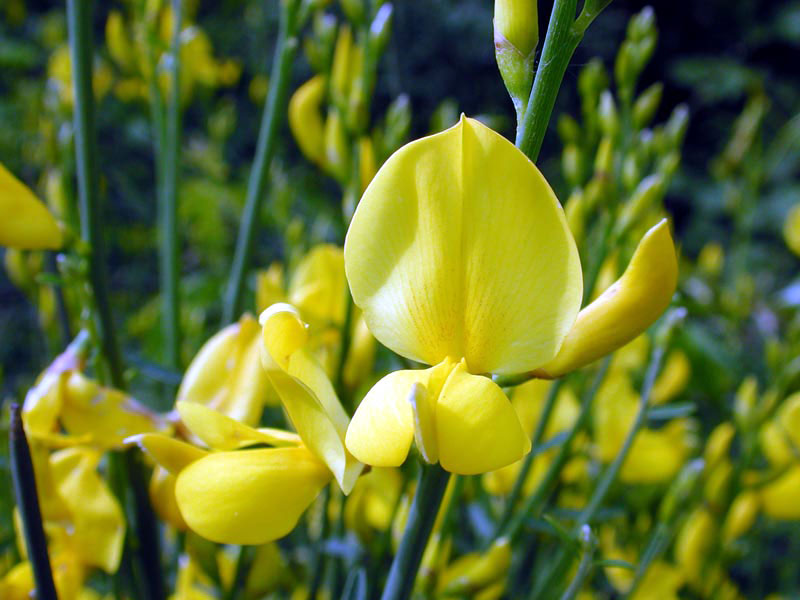
gullies, with their brooms, dog roses, chameleon plants, etc. form
favorable environments for the shelter of birds and mammals which
elsewhere, where the large cultivated fields have cancelled hedges and
tree rows, do no longer find favorable sites to shelter and rest.
The
unruled urbanization and industrialization of the valley bottom have
also contaminated the most fragile hilly areas, levelling the rural
landscape and impoverishing it of some essential features.
This is
the richness, but at the same time the fragility of our area which has
been threatened with the loss of its identity because of the pressing
requests of large stretches of land to designate to multiple uses, all
completely different from the original aims.
The Wildlife of the Balze
Besides being very useful for man, these small artificial lakes have
slowly renaturalized, transforming themselves in precious reproduction
areas for amphibians, insects, crustaceans, mollusks, and aquatic
plants.
They represent at the same time places where big aquatic
birds can stop: the Grey Heron, the Little Egret and, during the
nesting period, the Night Heron.
Also the several dry-stone walls,
more or less preserved, represent an ideal shelter where the fauna can
spend the cold winter months.
The cavities characterizing the
overhanging walls are used as a protection and nesting place and also
the flora, with its thick shrub formations at the foot of the gullies,
represents a shelter for birds and mammals. We have recently been
observing the more frequent presence of the Bee Eaters, very colored
birds living in the area only during the reproduction period and which
form small colonies made of 4 – 5 couples. These birds dig their nest
up to 2 meters of depth within the clayey gullies, and they seem to
have found here a particularly ideal area for their reproduction.
The
woodlands are also populated by small mammals like the badger, the fox,
the weasel, and the stone marten; the latter often reach the cultivated
areas, among the farmers' henhouses, looking for hens and other
farmyard animals. In the woodland we can also find rodents like the
dormouse and the squirrel, while in the most open areas it is possible
to sight the deer and several wild boars. The area is particularly
known for the great number of Hares which have found here an ideal
habitat.
![]() Further information (PDF, Italian text - 122 Kb)
Further information (PDF, Italian text - 122 Kb)
The Flora of the Balze
Walking along the trails crossing the territory, the visitor will be amazed not only by the charming landscapes, the Romanesque-style country churches, the medieval castles and towns, the farmsteads, but also by the different vegetation enriching these chains. The walls alternate or combine strata of sands with strata of gravels. The sands often form small terraces with steep edges marking a clear break with the clays lying underneath, well recognizable for the vegetational change: as a matter of fact, the clays house herbaceous plants, the sands shrubs and trees.
![]() Further information (PDF, Italian text - 52 Kb)
Further information (PDF, Italian text - 52 Kb)
The Watercourses
The
presence of Le Balze demonstrates that in the past the whole area was
covered by a big lake: as a matter of fact, they represent the ancient
shores of the large stretch of water. In subsequent stages, they have
been eroded by meteoric waters. Today the whole territory is
characterized by the presence of several watercourses coming from
Pratomagno, all affluents of the river Arno.
The streams of a
considerable size are not many: among the most important ones there is
the stream Resco, which in its initial stretch is divided in two
watercourses, one running in the province of Florence and the other in
the province of Arezzo, meeting in the country hamlet of Vaggio to form
a single watercourse. Always in the Municipality of Reggello, there are
Vicano, Marnia, Chiesimone, and Rio di Luco which are bound to reach
their maximum rate of flow in autumn and spring and which already at
the beginning of the summer are dry, unless there are storms and rainy
periods. In the province of Arezzo there are the streams Faella,
Ciuffenna, and Agna, all characterized by unassuming size and flow.
There are also other small watercourses, but they are small streams and
ditches of almost no value. Along these watercourses there is a humble
but lively lotic environment where several aquatic macroinvertebrates
live, like amphibians, fish and also birds, of course during the
periods of greatest water abundance.


