SP Road no. 173 of Assietta
- Trail Conditions: On foot, By bike
The military road called Strada dell'Assietta is almost entirely situated at an altitude of 2,000 meters along the ridge connecting Pian dell'Alpe with Sestriere and separating Val Chisone from Val Susa. It develops for over 30 kilometers within Gran Bosco di Salbertrand Park and walking along it represents a unique opportunity to discover some of the most significant events of the history of this extremely fascinating place set in the western Alps.
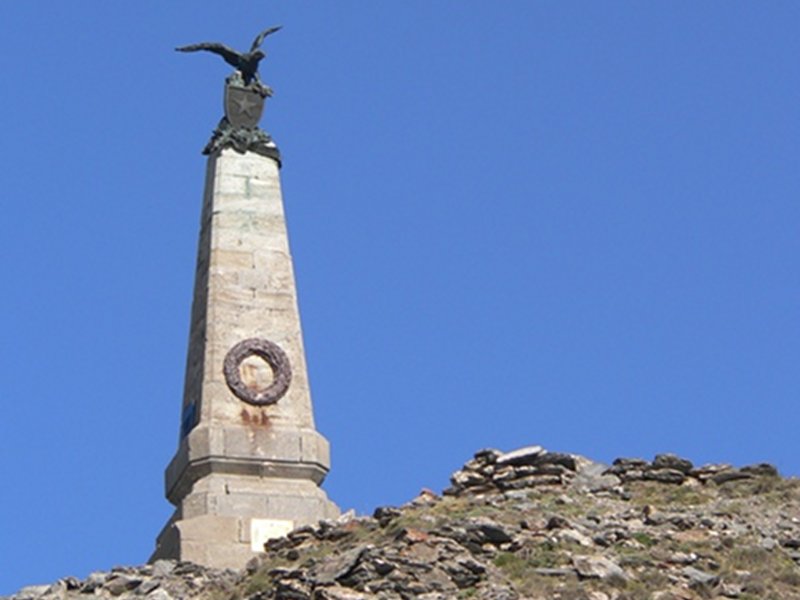
Coming from Pian dell'Alpe, after about 100 meters from the Park entrance, you will find the crossroads leading to Assietta summer mountain pasture, where you can also purchase dairy products directly from the farmers. Once you reach the ridge, there is a road leading to the fort of Gran Seren and from here it is possible to reach Arguel summer mountain pasture, in the village of Chiomonte towards Pian del Frais. Along Assietta road, beyond the homonymous relief (2,472m), you will reach Testa dell'Assietta (2,566m), where you will find an obelisk dedicated to the 1747 battle, a significant event of the War of the Austrian Succession, which was won by the army of the House of Savoy against the French led by the Earl from Bellisle. From here the descent towards Col Blegier begins: you will touch the former Track Maintenance House adjacent to Assietta Lake, which is going to be renovated thanks to a plan carried out by both the Province of Torino and the Park Authority. On the right side there is the crossroads leading to Testa del Mottas and farther on, on the left, the junction leading to Gran Costa. The GTA trail (Via Alpina, the Roads of the Waldensians) on the left develops downhill across the Park and then branches off to lead on the left to the Road of the Cannons until the junction with the road leading to Col Blegier and on the right to Grange del Seu, where you will find Daniele Arlaud Mountain Hut.
Following the SP road, after Colle Lauson you will reach Colle Blegier, from which a road closed to non-authorized motor vehicles (the Road of Blegier) leads across Gran Bosco di Salbertrand Park to Ser Blanc and from here to Monfol or eventually to Salbertrand. Going ahead towards Sestriere, you will reach Mt. Genevris (a 650m-long road closed to motor vehicles leads to Faro degli Alpini given by the Italian Navy), to Colle di Costa Piana and to Colle Basset.
During the winter, the SP road of Assietta is closed to the traffic (from 1st November to 31st May). Since 2007, during the summer, the road is subject to an enhancement and traffic regulation plan.