


Carta dei Sentieri del Parco Regionale della Vena del Gesso Romagnola - Scala 1:25.000
Official hiking map
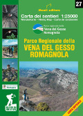
The Park Hiking Map is published thanks to the meticulous work of Ente Parchi Romagna, CAI Faenza, Imola and Lugo, and Editore Monti.The Map shows all the hiking and MTB trails, ways (including the new Gypsum Way) and thematic trails, visitor centres, education places, visitable caves, reception structures and information points.
The map can be found in the book shops, newsagents, information points and online.
- Scale: 1:25.000
- Price: free
Carta dei Sentieri del Parco Regionale della Vena del Gesso Romagnola - Scala 1:25.000


© 2024 - Ente di gestione per i Parchi e la Biodiversità - Romagna