

Points of Interest
The protected area of the Antola has been divided into three areas according to the regulations of the Park Plan:
- ZONE B or "riserva generale orientata"
- ZONE C or "area di protezione"
- ZONE D or "area di sviluppo"
and in adjacent areas which are functionally linked to the Park area.
Zone B or "Riserva generale orientata"
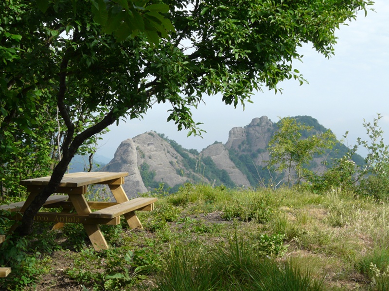
The Park Plan considers the ZONE B the most interesting area of the Park, that is the area of Rocche del Reopasso.
- Rocche del Reopasso
The Rocche, consisting of large Savignone conglomerate outcrops, date back to the Oligocene period and house a particularly interesting flora and fauna. They represent one of the favorite destinations for hiking and mountain climbing.
The area lies in Oasi del Reopasso (1,221 hectares), which is of particular interest for the protection of the avifauna: for the first time, the nesting of the Lesser Spotted Woodpecker has been ascertained; moreover, another fifty species - almost all nesting species - have been sighted. Among the others, the Short-toad Eagle and the Honey Buzzard.
ZONE C or "Area di Protezione"
The ZONES C or "aree di protezione" (protection areas) involve most of the Park and they are characterized by the presence of naturalistic and environmental features of great value linked to particular cultivations, agricultural productions, and models of settlement. The aim of these areas is to maintain rural landscapes of great interest, important for the experimentation of active safeguard measures.
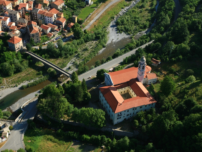
In Montebruno, one of the Municipalities of Val Trebbia in ZONE C, there is "Museo della Cultura Contadina", with the Sanctuary attached. The Museum is articulated into different sections illustrating the hard work of the population who shaped in the past the rural landscape of these valleys. Montebruno Sanctuary is of particular interest.
- Montebruno Sanctuary
The Sanctuary, whose adjacent Convent is one of the most interesting sections of the monumental complex, was built in 1486 by the Augustinian monks to remember the 1478 miraculous apparition of the Madonna to a young mute shepherd. The population found in the location of the "miracle" a wooden statue of the Virgin Mary on a beech tree; nowadays the statue has been placed on the High Altar; the interior is Gothic, while the ornaments and the decorations are of Baroque style; there are valuable frescoes and paintings, and a precious wooden Crucifix dating back to the 17th century.
In the Sacristy you will find some azulejos dating back to the first half of the 16th century, probably built according to the Sevillan method.
In Busalla, one of the Municipalities of Valle Scrivia whose territory is partially in ZONE C, there is a Sanctuary which is worth a visit:
- N.S. della Bastia Sanctuary
The Sanctuary, deriving from the expansion of a pre-existing country chapel, is dedicated to the Virgin Mary. It is linked to the finding of a small statue of the Virgin at the half of the 17th century. The statue has been placed in a fissure of the rocky rampart.
Near the Sanctuary it is possible to observe the point of contact between the marly limestones of the Antola and the Savignone conglomerate.
ZONE D or development area
The ZONE D or "aree di sviluppo" (development areas) are particularly important areas for the Park. They have considerable naturalistic aspects to safeguard and are characterized by the presence of structures housing useful activities and services for the enjoyment of the Park and for the economic development of the whole area. Among them:
- The Summit of Mt. Reale
On Mt. Reale (920m) there was an ancient Castle which has now disappeared; on the summit of the mountain a small Church dedicated to Madonna di Loreto was built in 1858 together with a mountain hut. It is one of the most visited mountains of Valle Scrivia by hikers; as a matter of fact, from Reale it is possible to enjoy a wonderful view of the Alps! - Castello della Pietra
Going along Val Vobbia, after a few kilometers from the highway exit of Isola del Cantone, you will find Castello della Pietra.
Looking at the castle from the bottom of the valley, you can see that it is situated in a strategic position, since the rocky towers (puddingstone, Savignone Conglomerate) between which it lies make it an impregnable fortress.
It was built around the year 1000 by the Bishops of Tortona, probably against the Saracens, to watch over the road linking Vobbia to Isola del Cantone, therefore Via del Sale to Via Postumia in Valle Scrivia.
The town of Vobbia was born as a trading center along the Road of the Imperial Feuds (Via del Sale) linking Genua to the towns of the Po Plain.
Subsequently, the Castle passed to Marquis Gavi in 1050, and then to Malaspina Family and in 1252 it became property of Opizzone della Pietra, whose name derives from the purchase of this feud. Opizzone was also the one and only feudal lord to live in it, since the castle was usually inhabited by privileged families in the lord's employ.
The Castle belonged to Opizzone's descendants until 1565, and afterwards to Botta Adorno until 1797 (year of the abolition of the Imperial Feuds of Liguria). It was set on fire by the Napoleonic troops and its five cannons were melt to build the bells of the church in Crocefieschi.
In 1882 it passed from Botta Adorno's descendants to Cusani Visconti who in 1919, ignoring an ancient prohibition, gave the castle to Beroldo family. In 1979, Beroldo gave the Castle to the Municipality of Vobbia.At the end of the 70s the Province of Genova, in collaboration with the Municipality of Vobbia, Centro Studi Storici per l'Alta Valle Scrivia e località viciniori, Soprintendenza ai Beni Archeologici della Liguria and some volunteers, began a restoration plan lasting ten years, thanks to which today it is possible to visit the castle.
The visit to the Castle can be divided into five sections:
- Trapezoid Projecting Part: it protected the main body and was probably used as storehouse or prison
- Central Hall: here the social life of the castle used to take place; three openings offer a breathtaking view over Val Vobbia
- Patrol Trench
- Upper Hall: one and only indoor hall of the Castle where you can see the upper part of the vaulted ceiling of the Central Hall
- Access to the Main Tower (not accessible at present)
Opening: The Pietra di Vobbia Castle is open on Sundays and holidays from Easter Monday to October included, entrance and guided visits every hour from 10.30 am to 5.30 pm (last entrance allowed).
Entrance tickets:
- Full-price ticket 5.00 Euros
- Reduced-price ticket 4.00 Euros (For groups of at least 20 people, 6 to 12 years old children, over-65 people)
- Free for under-6 children, for tuorist guides and guides for people with disabilities
For groups of at least 20 people and for school groups it is possible to organize visits on working days.
For further information contact the Park Authority +39
010 944175.
- Valbrevenna Ecomuseum
Valbrevenna preserves uncontaminated natural environments together with evidences of the Valigiana culture which must be safeguarded (ancient mule tracks, bridges, rural architectures...).
For these reasons, the idea of the ecomuseum was born: thanks to it, the territory can be enjoyed through thematic itineraries describing the characteristic aspects of the rural culture of this valley. The suggested itineraries deal with four main issues:
- rural architecture: lime production and building techniques
- chestnut civilization: from diet to carpentry
- the so-called "fasce": the traditional dry-stone walls built by the masters of the past
- the stable: exploitation of community pastures, hay making, milking, breeding, cheese production…
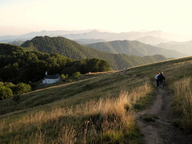
- Summit of Mt. Antola
The name of Mt. Antola (1,597m) probably derives from the Greek "anthos" which means "flower". There are several rare and protected species in Liguria, like lilies, gentian, orchids, buttercups… and many aromatic and medicinal species like the arnica. You can also admire beautiful butterflies and enjoy wonderful views by going along the several itineraries leading from the Borbera, Scrivia, and Trebbia valleys to this orographic junction.
- Brugneto Lake
Following the panoramic ridges of Trebbia upper valley, you can enjoy the wonderful setting of Brugneto Lak. It is an artificial basin resulting from the building of a dam 260m long and 80m high, with a capacity of 25 million cubic meters of water which submerged in the past the ancient towns of Casoni and Frinti, and which represents the main water reserve of the town of Genova.
Naturalistic features - woodlands alternating with meadows and cultivated areas - and architectural features - among which ancient mills and stone bridges - are the main interesting things along the panoramic ring-route bordering the lake and mainly developing along ancient mule tracks.
- Astronomical Observatory - Casa del Romano
Within a valuable natural landscape the Astronomical Observatory Parco Antola, municipality of Fascia, is situated in the Alta Val Trebbia, in the locality of Casa del Romano, at an altitude of 1,406 m.
The unique structure in Liguria, as far as its location and equipment are concerned, is managed by the Park which for the organization of the activities with the visitors and the school groups avails itself of the support of Urania, one of Italy's most ancient associations for the study and spread of astronomy, which was founded in Genoa in 1951.
The structure is equipped with a digital planetarium simulating the sky through the projection of images on a fixed dome with a 6 m wide diameter.
You can comfortably sit on recliners to watch multimedia projections, thematic videos, didactic animations and simulations of astronomical phenomena (eclipses etc…). Furthermore, the observatory is equipped with a dome hosting a telescope with an 80 cm large opening (among the largest ones in Italy).
Entrance tickets
Day and night ticket
- Full-price ticket 7 Euros
- Reduced-price ticket (over-65 people, children aged between 6 and 11) 5 Euros
- Family (Parents and one child 14 Euros) - (Parents and 2-3 children 18 Euros)
- Under-6 children free entrance
Further information: - Urania Association: +39 333 9355539 – associazioneurania@tiscali.it – www.osservatorio-parcoantola.it
- Antola Park: +39 010 944175 – info@parcoantola.it – www.parcoantola.it
Adjacent Areas Functionally Linked to the Park Area
The adjacent areas, although not within the protected area, are territories which are functionally linked to it; among the characteristic towns of these areas there are:
- The Town of Pentema
During the months of December and January, the atmosphere of the Nativity of Christ revives in a picturesque setting among the cobbled paths, the alleys, the arches, and the interiors of the historical town center of Pentema (see www.comune.torriglia.ge.it/pentema.asp or www.pentema.it) which, until a few decades ago almost entirely isolated, has preserved its original features.
The Christmas Crib involves the whole village with a reconstruction of the aspects of past everyday life, places, and trades of the 19th century. This representation aims at bringing out the popular religious tradition and evoking the values of simplicity and authenticity characterizing the life of the inhabitants of Pentema in the latest century.
It is possible to visit the Christmas Crib from mid-December to the end of January, on Saturdays and Sundays 10.00 a.m. - 6.00 p.m. (from the 24th December to the 6th January, every day).
The Village of Senarega
- Senarega (711m above sea-level), in Brevenna upper valley, is one of the most important medieval villages in the Park on the slopes of Mt. Antola; it is interesting from a historical and architectural point of view:
- the medieval Senarega-Fieschi Castle, consisting of a square tower dating back to the 12th century and of the attached palace
- the Parish Church of N.S. Assunta (13th century) and the Parsonage
- the Oratory (17th century) and the Chapel of N.S. delle Grazie (17th century), next to the ancient stone bridge over Rio dell'Orso
- the characteristic rural buildings
- the rural museum.
- Further information
- Chiappa (890m above sea-level), in a wonderful panoramic position over Val Brevenna, is a charming rural town about 2 km far from Senarega; it is surrounded by mixed woodlands of broadleaf trees, it preserves the typical aspect of a small agricultural center with stone-paved roads; by going along these roads, it is possible to observe the typical houses of Chiappa, some of which are characterized by roofs in "ciàppe", characteristic of the area, from which the place name derives.


