Water Itinerary
Rufiedo Springs and Lakes
- Trail Conditions: On foot
Sparkling jets of water magically burst out from Croda Rossa
From the car park of Lago Bianco, follow the road leading to Lerosa for about one kilometer, until you reach the first and the smallest of the many streams forming the so-called "Fontane di Rufiédo" (Rufiédo Fountains). Beyond it, crossing the most raging streams on various small bridges, you will cross the whole area of the springs – a few hundred meters – until the waters run dry. For the return journey, you will follow the way of the outward journey.
The great strength and quantity of water with which Rufiédo springs come out from the ground in some periods of the year witness the extent of the basin feeding them. However, observing this slope of Croda Rossa, you cannot see big valleys that could give origin to such a big watercourse. The only reason that can explain such an extraordinary and anomalous situation is the presence of karstic channels that can carry big quantities of water from the highest and largest basins of Croda Rossa up to the heart of this woody and uniform slope.
The flow, in some days very raging, breaks on the several rounded and mossy boulders filling the steep bed of the stream; this creates a water nebulization effect filling the surrounding woodland with its steam and noise. After the snow-melting period or after a period of drought, the flux almost suddenly interrupts, depriving the underlying lakes of the water supply and drying up the moss covering the riverbed; only from the central fountain, the water continues to spring out. Such intermittent flow is characteristic of the karstic springs.
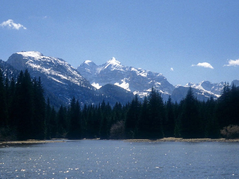
Once you are back in the car park of Lago Bianco, cross the road and follow for a short stretch the former railway line towards south-west until you reach, with a short detour on the left, the northern shore of Lago Negro. Here, before going back, you can decide to follow the former railway line and reach Lago de Rufiédo and its affluent, that will lose itself in the thick stratum of detritus of Pian del Forame, and will re-emerge from the gravel near the rich Foràme springs.
In the first half of June, along the shores of Lago Negro it is possible to admire the wonderful blooming of the Bird Cherry (Prunus padus), growing in big bushes near the water. It will also be possible to sight some couples of mallards (Anas platyrhyncos), concealing themselves among the equisetum or lying on the emerging stones to dry up.
At the south-western edge of Lago de Rufiédo, the water comes out very slowly and continues almost stagnating up to Felizon Valley, until the slope increases and the stream recovers its normal flux. The reason for this "effort" and for the trend of the water to flow north-east at the arrival of Rufiédo in the valley bottom depends on the fact that, once, this stream coming from Valle di Gótres used to flow down in the opposite direction, towards Carbonin and Val Rienza and that the old watershed between Felizon-Boite-Piave and Rienza-Isarco-Adige basins used to be here.
A big post-glacial landslide fallen from Croda Rossa invaded then the valley bottom in the north, creating the new Cimabanche pass and obstructing the course of the stream towards north-east. This led to the creation of Rufiédo Lakes, characteristic "barrage" lake, from which the water has gradually found an outlet in the opposite direction, flowing down towards Felizon valley. This phenomenon, not so unusual, caused for rio di Gotres and Rufiédo the abandonment of Rienza basin and the confluence into Felizon, and is known as "river capture".