


Points of Interest
The Natural Environment
Along the ridge of Mt. Subasio we can distinguish some isolated
summits, the most important of which are, from north to south, Mt.
Subasio (1,290m), Mt. Civitelle (1,280m), and La Sermolla (1,191m).
Moreover, you can see Colle San Rufino (1,110m) in the north-western
end and Madonna della Spella (978m) in the south-east of the mountain;
in the south, separated from Fosso Renaro valley, Mt, Pietrolungo
(914m).
Its characteristic rounded shape and the towns of Assisi
and Spello developing on its slopes make it easy to recognize Mt.
Subasio in the plain of Umbria.
The Mountain is a natural frame linking and dividing at the same time
the historical towns of Assisi, Spello, Valtopina and Nocera Umbra as a
unifying element of the landscape.
Its
summit, mainly flat and characterized by evident karstic phenomena,
clashes with the steep slopes mainly characterizing its eastern section.
The slopes of Subasio are covered today with an arboreal vegetation
that can be divided into three strips: the first one is characterized
by olive trees, whose cultivation goes from Assisi to Spello on both
slopes and from Costa di Trex to Armenzano and San Giovanni; the second
strip is characterized by a natural arboreal vegetation of Turkey oaks
and downy oaks, hop hornbeams, flowering ashes, maples, beech trees,
and holm oaks; high forests of resinous plants, due to reforestation
activities, characterize the third strip together with high-mountain
grazing meadows.
However,
despite its great variety and despite hunting was banished several
years ago, the natural environment houses a poor wildlife: wolves are
occasionally seen, and the golden eagles lived here until the 60s
together with the rock partridge.
The actual mountain management
favors the new colonization by the grey partridge, the wild cat, the
squirrel, the wood pigeon, the magpie, the jay, as well as the
porcupine, the badger, the fox, the weasel, the beech-marten, and the
wild boar.
Among birds of prey, in particular in the eastern section of the Park, there are the buzzard, the goshawk, and the scops owl.
The History of Man and his Signs
Since ancient times, the slopes of Subasio have been inhabited by man.
Assisi and Spello are the two most significant settlements: they have
documented Roman origins, but several traces of more ancient
populations (Umbri). Therefore, in the territory of Mt. Subasio
history, nature, and culture merge. As a matter of fact, Monte Subasio Park is not only characterized by a great naturalistic heritage, but also by
an extraordinary human heritage very rich in ancient traditions,
natural beauties, artistic-architectural, as well as spiritual and
religious values. In it, nature well combines with the millenary human
presence that has left several evidences.
St. Francis gave this area
a perennial fame all over the world, which combines with the fame of
the matchless artistic treasures enriching the churches of Assisi, the
charm of its streets and squares, the panoramas over the plain, the
Holy Monastery and Basilica, Eremo delle Carceri set among ilex trees
and oaks, and the ancient S. Damiano Monastery.
The Most Important Environmental Aspects
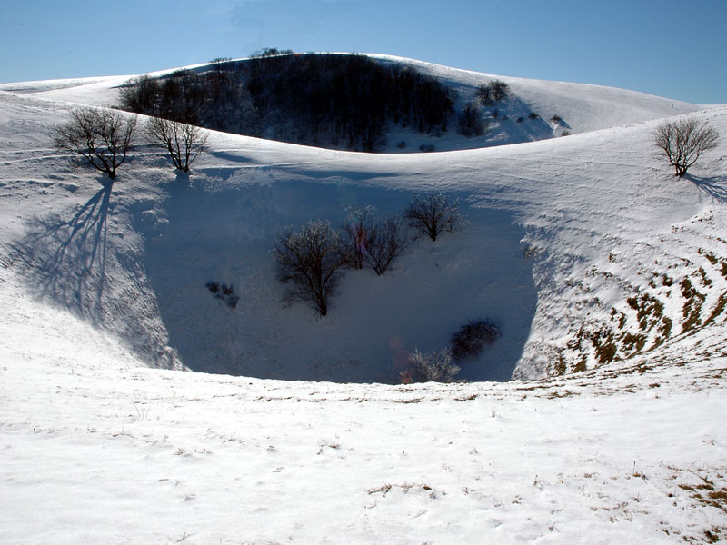
The so-called "Mortari"
Among the most important and
evident phenomena, there are "Mortaro Grande", "Mortaro Piccolo" or
"Mortaiolo" and "Mortaro delle Trosce".
The name derives from their resemblance with the homonymous home tool, the mortar.
They are situated on Mt. Civitelle. They have rather steep walls and a rounded bottom. They are approximately 50m deep.
- "Mortaro Grande" is an elliptic-shaped doline whose major axis measures 260m. It has a depth of 50/60m and is the largest doline on Mt. Subasio. It has rather steep walls. It originated from a collapse of the bottom caused by the non-stop erosive action of water.
- "Mortaiolo", adjacent to the former, has a diameter of 70m and a depth of about 60m. Towards the bottom, the walls are rather steep.
- "Mortaro delle Trosce" is situated in the south-eastern section of Subasio.
Similar in size to Mortaiolo, it has a rounded shape.
Further Karstic Phenomena
Orrido delle Carceri The swallow hole collects the infiltration waters in a big hypogean cavity.
According to a popular legend, it fills up with water only in case of war or events of particular importance.
Vallonica Karstic Basin After Eremo delle Carceri, once you cross the homonymous ditch, at Rifugio Vallonica you will find Vallonica basin, a karstic basin - originally closed - which derives from the erosive action carried out by the ditch itself. It has an elliptic shape. Nearby there is also a small well.
Subasio Cave Situated at 1,050m a.s.l. at Sasso Piano, it is a 18m well giving access to a cavity which is approximately 30m deep.
Mt. Pietrolungo Lake lies along the mountain summit road, before Collepino. It is a flat-bottom doline with a well and water on the bottom.
On Mt. Subasio there are several dolines
- Fossa Rotonda is a complex doline with an elliptic shape situated in the north-west of the summit. The largest diameter is about 100m, the depth is 12m.
- Not far there is Fossa Cieca, with a 17m diameter.
The depressions of Mortaro Grande and Mortaro Piccolo have represented for centuries a stock of ice, working as real fridges. The snow which fell during the winter was squeezed in the dolines so that it could last for a long time: in case of need, it was cut into blocks, transported to the valley and then sold for the conservation of food.
Text taken from "Parco del Monte Subasio", © Quattroemme, Perugia 2006. All rights reserved.
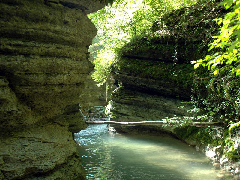
Fosso Marchetto Ravine
Charming ravine dug by the
waters of Fosso Marchetto. Everyone here can practice canyonism to
enjoy the spectacular features of the canyon, since you do not need
particular equipment for the lack of significant drops. However, you
will need a diving suit and if you are not expert, it is recommended to
be led by a qualified guide.
Eremo delle Carceri Ilex Wood
It
is a very interesting example of high-trunk ilex wood and has always
been protected by the friars who have been living on the mountain since
St. Francis times.
Macchione Beech Tree Wood
The
large beech tree woods of the past are now limited to some areas, the
largest of which is known as Cacchione situated between Armenzano and
Costa di Trex.
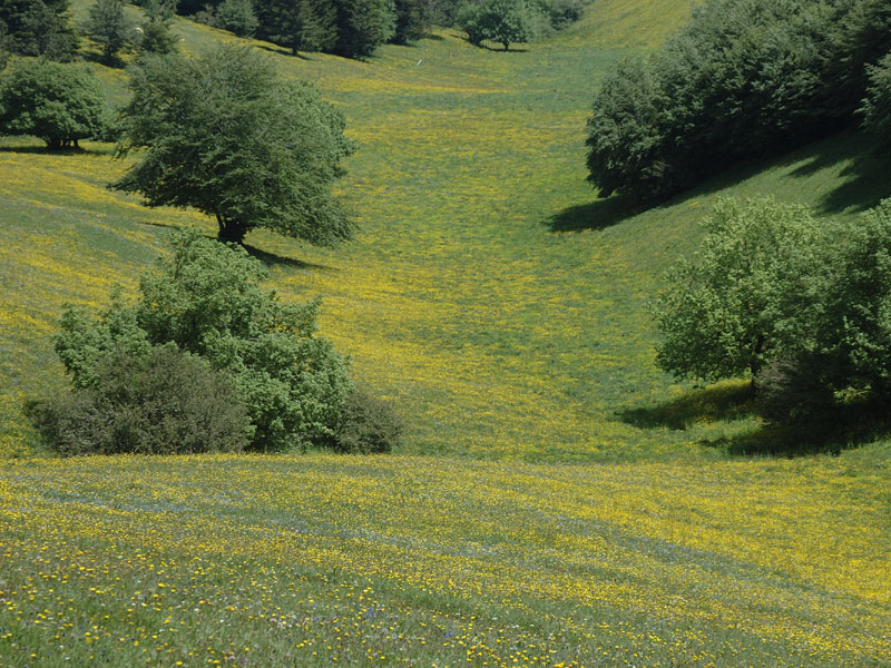
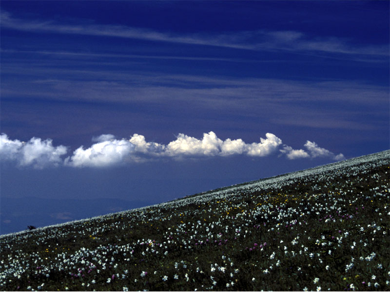
High-mountain Meadows
They are perennial grasslands covering an area of 1,190 ha.
These
meadows are colored in spring by several flowers, among which the
narcissus, which is the flower of Mt. Subasio. This flower, today
protected like all the other floristic species, was gathered in the
past on the Ascension Day to make the traditional "mazze fiorite".
Colli di Selvalonga
Area characterized by large woodlands of Turkey and downy oak.
Cultural Heritage
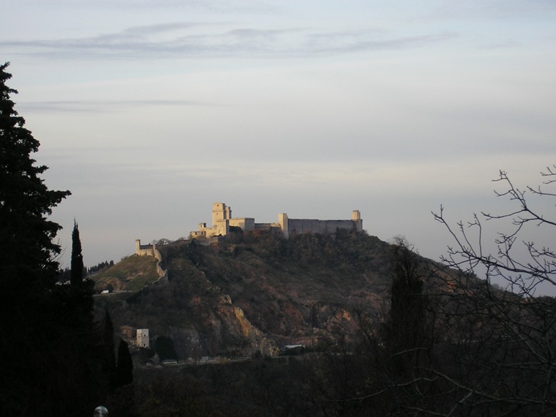
Assisi
Subasio is "Monte de Assisio" since Assisi and its mountain live since ancient times in a sort of symbiosis which, over the centuries, has become stronger and deeply rooted. The whole town center of Assisi lies within the Park and characterizes its natural and historical-cultural features, to the extent that the Protected Area could also be called "Parco di Assisi".
The town was built with the pink stone taken from its mountain and Subasio geomorphological balance and wildlife and vegetational features are determined first of all by the fact that it is the mountain from which Assisi has always taken its resources: from the stone material to timber and products deriving from the grazing activity.
Assisi, Umbrian acropolis first and important Roman municipium later, began to take shape exactly on the Roman town with its terracing, the square of the Forum where the main roads ended and where Minerva Temple still faces. In the early Middle Ages, settlements grew within the town walls on the ruins of the Roman buildings.
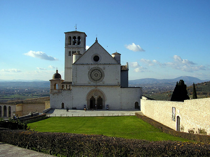
The most ancient churches date back to the period before the year 1000: it is possible to find evidences of them in the crypts of S.Maria Maggiore and S.Rufino. However, Assisi mainly preserves evidences of centuries of Franciscan spirit, centuries of devotion, and centuries of religious estheticism. Here you are Basilica di San Francesco with the frescoes decorating both the lower (Simone Martini, Cimabue) and upper basilica (Giotto), Basilica di Santa Chiara, San Damiano church.
Assisi has been declared World Heritage Site by UNESCO.
Strolling around the Park...
In the Park there are towns, fortresses, bridges, drinking troughs.
Churches, sanctuaries, monasteries, abbeys, oratories, aediculae
increasing the historical and architectural value of the territory. All
these small but imposing works, set in a frame with strong agricultural
and rural connotations, represent the main tourist attractions of the
territory.
Towns
- Armenzano
It is situated at the summit of a hill at the mouth of Fosso Marchetto valley. A typical example of settlement of feudal origin developing in the communal period, it has a compact structure and an almost circular plan delimited by a ringroad. The walls are well preserved; from the in-the-round entrance arch, a pedestrian street climbs with a spiral route to the caisson dominating the whole complex.
- Costa di Trex
It is situated in a panoramic position at 573m a.s.l. and faces the river Tescio and Fosso Marchetto.
Its name derives from a contraction of "Costa delle Tre Chiese": in particular, the name refers to Santo Stefano church (on the outer wall there is an urn of Roman epoch), San Bartolomeo church, and San Lorenzo church, which is private property. - Collepino
Not far from Spello, going along a road surrounded by olive trees - a typical cultivation of the area - there is the town of Collepino. Its origins date back to the early Middle Ages and is a characteristic town surrounded by walls.
- San Giovanni
Along the road connecting Spello with Assisi, between Collepino and Armenzano, there is San Giovanni town-castle. It opens towards Topino valley and behind the town, on the slopes of Subasio, Macchia di Pale extends to the high-mountain meadows.
In the town church, where according to the tradition St. Francis performed one of his miracles, there are 17th century frescoes.
- Lanciano
Lanciano is a country hamlet of the Municipality of Nocera Umbra.
The term Lanciano derives from the Latin Lantius, the name of the ancient owner of these lands.
The town represents the development of an ancient fortified settlement which originally worked as a watchtower. The urban structure of the settlement degrades to the hill slopes dominated by the medieval tower and develops on the two sides of the ancient connection road. In the highest point of the country hamlet, at 676m a.s.l., the small church of Lanciano rises.
Churches
- San Vitale Church
On the slope of Mt. Subasio facing south there was San Vitale hermitage, now parish church of Viole, country hamlet of Assisi. Next to the church there is Fonte di San Vitale, already reconstructed in 1756 and recently renovated in 2001. - Madonna della Spella Church
Built in the 11th century on a hill (958m a.s.l.) of Subasio slope going down to Collepino and from here to Spello.
The name derives from specula, that is "panorama", since here you can enjoy beautiful views reaching Sibillini Mountains.
- Madonna di Colpernieri Church
It is a small building situated on a hill halfway Collepino and San Giovanni.
Behind the main altar there is a canvas representing Madonna della Provvidenza.
- Madonna dei Tre Fossi Church
It is situated in Valle del Tescio and is an elegant and simple stone building with belltower.
Abbeys and Hermitages
- Eremo delle Carceri
St. Francis used to come and prey in the caves where subsequently the Hermitage was built (carcerava, from here the name "delle carceri"). Together with the centuries-old ilex wood, it is one of the most significant environmental features of Mt. Subasio.
- San Benedetto Abbey
It has very ancient origins. In the 13th century it was a monastic seat depending on the abbey of Farfa.
The Romanesque-style is particularly evident in the outer structure.
The crypt dates back to the 11th century.
- San Silvestro Abbey
The church is what remains of the big monastic complex probably founded by St. Romualdo in 1025. Above the altar, a 15th century Madonna with Child.
In the crypt, some capitals of Roman origins have been re-used.
Nearby, there is San Silvestro spring which seems to have therapeutic properties.
According to the tradition, here St. Francis and St. Clare lived for some time.
Bridges
On the river Tescio delimiting the northern
border of the Park, there are several ancient bridges which favored
both the trade with the nearby Marches and the pilgrimages.
They
represent secondary ways of communication used to connect the two parts
in which the river Tescio divides the homonymous valley and are linked
to the presence in the area of several watermills.
- San Vittorino (or Vetturino) Bridge of 1283, reconstructed in 1514.
- First Bridge of the Gauls (1193), under restoration by the Park
- Second Bridge of the Gauls or Ponte Santa Croce (1353-1357)
- Ponte Dolci (first half of the 19th century).
- Hannibals' Bridge or Pontaccio (collapsed in 2001)
- Ponte Grande (1469)
- Marchetto Bridge (medieval epoch)
- Cavaliero Bridge (17th century).
Resurgences
Given the rounded shape of Subasio and its
calcareous nature, most of the meteoric waters go under the ground and
reach impermeable strata. The water then reappears from the mountain as
springs that man, over the centuries, has learnt to manage creating
fountains and drinking troughs, and sometimes also channels to use this
water in the aqueducts of the nearby towns.
- Fonte Bregno (at the edge of the border between Assisi and Spello)
- Fonte Maddalena (near Costa di Trex)
- Le tre Fontane (near Eremo delle carceri)
- Fonte Sermattei (situated in the abandoned town of Gabbiano Vecchio)
- Fonte del Brecciaro (along the road leading to Armenzano)
- Fonte San Silvestro and Fonte San Benedetto (situated in the homonymous abbeys)
Comunità
Montana Monte Subasio has implemented several measures for the
maintenance and recovery of these springs mainly caused by the long
periods of drought.
In the Park Surroundings
- Spello
The town is situated on a hill in the south of Subasio massif. It boasts Roman origins, as demonstrated by the southern walls, Porta Consolare, Porta Venere, Porta Urbica, and the amphitheater. Spello is a typical medieval town: narrow and winding streets, ogival arches, squares, towers, flights of stairs, façades with Subasio pink stone. The churches preserve real works of art of the Umbrian school. At the end of the 15th century Pintoricchio, in Santa Maria Maggiore, in Bagioni chapel, painted some of his most important works.
On Corpus Christi Day, wonderful flowerbeds cover the streets and squares of the town. These are real works of art surviving only for one day.
- Nocera Umbra
It is set among gentle hills, not very high mountains, and large valleys. The town was founded by the Umbrians and flourished above all in the Roman epoch after Via Flaminia was built. The town center has a medieval urban structure.
Important monuments are San Francesco Church (preserving the works by Niccolò Alunno and Matteo da Gualdo) and the Cathedral.
The territory is characterized by the abundant and precious presence of several water springs which, over the centuries, have been completed by baths and bottling plants.
In August in Nocera Umbra, "Festa delle Acque" and the famous "Palio dei Quartieri" are held.
- Valtopina
This town was named after the valley of the river Topino, where it is situated. This territory was interested by the human presence already in the Paleolithic Age, but its importance grew after Via Flaminia was built in the Roman Age. There are several evidences dating back to the 4th century B.C. and Roman finds between Collettaia, Pieve Canonica, Ponte Rio, Poggio.
In the Middle Ages it was in the middle of a complex system of castles and a mosaic of monasteries, towns, and fortresses. Santa Cristina Church is worth a visit: it was built with the stones of Poggio castle, of which only the imposing tower remains.
Near the town there is Molini Buccilli, a watermill which is still perfectly working, situated at the confluence between Fosso dell'Anna and other streams.
- Rivotorto
It is situated at the foot of Mt. Subasio, near Assisi. Santa Maria di Rivotorto Sanctuary preserves the so-called "Sagro Tugurio", where St. Francis gathered his friars before using "Porziuncola" of Santa Maria degli Angeli, where the Franciscan order was founded.
- Santa Maria degli Angeli
A few kilometers from Assisi, there is Basilica di Santa Maria degli Angeli preserving the so-called "Porziuncola", a particularly beloved place for St. Francis, and "Cappella del transito", built where the Saint died.


