Protected Area
Identity Card
- Oglio Sud Regional Park:
- Land Surface Area: 12'800.00 ha
- Protected flora: 2 species (Italian text)
- Protected wildlife: 222 species (Italian text)
- Habitats: 9 types (Italian text)
- Regions: Lombardia
- Provinces: Cremona, Mantova
- Municipalities: Acquanegra sul Chiese, Bozzolo, Calvatone, Canneto Sull'Oglio, Casalromano, Commessaggio, Gazzuolo, Isola Dovarese, Marcaria, Ostiano, Pessina Cremonese, Piadena Drizzona, San Martino Dall'Argine, Viadana, Volongo
- Establishment Measures: LR 17 16/04/1988
- Park Authority: Ente Parco Regionale Oglio Sud
- Further managed Protected Areas:
- Riserva Regionale Le Bine
- Riserva Regionale Torbiere di Marcaria
- Zona di Protezione Speciale Parco Regionale Oglio Sud
- Zona Speciale di Conservazione Bosco Foce Oglio
- Zona Speciale di Conservazione Lanca Cascina S. Alberto
- Zona Speciale di Conservazione Lanche di Gerra Gavazzi e Runate
- Zona Speciale di Conservazione Le Bine
- Zona Speciale di Conservazione Torbiere di Marcaria
- Zona Speciale di Conservazione Valli di Mosio
Altimetry: h min 19m asl - h max 31m asl
The Territory
The river Oglio springs from Stelvio mountain group; the main spring,
at the foot of Corno dei Tre Signori, gives birth to the branch Oglio
di Arcanello which in Ponte di Legno joins Oglio Narcanello and Oglio
Frigidolfo to create the main river flowing for 80 kilometers in Val
Camonica. The river Oglio flows into Iseo lake and flows out of it in
Sarnico.
In 1988 with the regional law no. 18 of 16th April, Oglio Nord Regional Park
was established: it includes the river territory from Sarnico (BG) to
Gabbioneta (CR) and involves 34 Municipalities in the Provinces of
Bergamo, Brescia, and Cremona.
In 1988 with the regional law no. 17 of 16th April, Oglio Sud Park was established.
The territory of Oglio Sud Park
extends itself, with a width varying from a few hundred meters to more
than three kilometers, along the whole course of the river, going from
the border with Oglio Nord Park in the Municipality of
Ostiano (CR) to the confluence with the river Po, into which Oglio
flows after a course of about 70 kilometers in the Provinces of Cremona
and Mantua: for long stretches, the river marks their administrative
border.
The Park covers a total area of about 12,800 hectares.
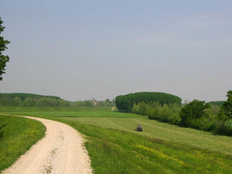
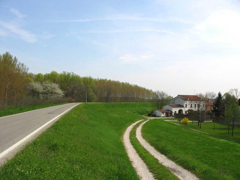
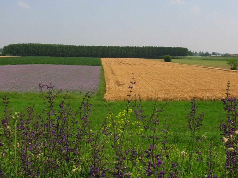
The landscape is characterized by agricultural activities where the
thick water network, often marked by scrub strips and tree rows and
developing along the plains surrounding the river, interrupts the
ordered sequence of cultivated fields. The areas between the low-water
riverbed and its banks stand out in the countryside for their imposing
poplar woods and, in some stretches, for their thick borders consisting
of white willows, which sometimes extend and form real willow scrubs.
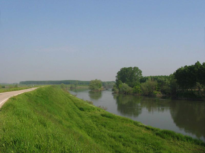
The bed of the river Oglio is characterized by a winding and one-canal
course with some well-evident meanders and often steep banks, at the
foot of which in summer you can see large sand beaches. The Park is
nowadays mainly characterized by wetlands at different evolution stages
and with floristic and wildlife diversity, while the natural forest
elements are not that significant and are mainly situated along the
shores, delimiting the course of the river.
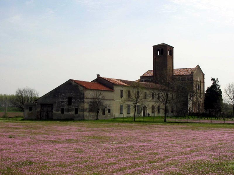
The main naturalistic features of the Park are Gerre Gavazzi and Runate Oxbows Nature Reserves, Le Bine, Marcaria Peat Bogs,
and S. Alberto Flood Plain, as well as other sites which are not
reserves but Sites of Community Importance (SCI), in particular: Valli
di Mosio and Bosco Foce Oglio. Moreover, for their naturalistic value,
we should mention Canale Bogina, Foce Chiese and Calvatone willow
groves, and Belforte Peat Bogs.
Vegetation
The natural vegetable formations present in the Park cover about 200
hectares, 1.6% of the total area, and distinguish themselves for the
prevalence of wetlands on woodlands. The relative shortage of wetlands
in the Po Plain and their gradual reduction along the major rivers have
transformed them in very important natural areas.
For instance,
between the Municipalities of Canneto sull'Oglio and Marcaria, the best
natural marshy associations can be found, together with floristic
elements which are typical of the original vegetation.
Near the ponds of the oxbows, you can also appreciate the gradual
sequence of the vegetable species as you leave from the stretch of water,
a sign of their increasing link to this element: from the canebrake to
the willows, to the alders and white poplars, to the oak wood. This
sequence is particularly evident in the Nature Reserve "Le Bine", in
the Municipality of Calvatone (CR), on the top of the bank bordering
the Reserve in the south and in the west, and also around the borders
of Golena di S. Alberto in the Municipality of Marcarla (MN).
As a consequence, there is the need to safeguard these residual ecosystems, for several reasons:
- because they enclose what remains of the biological varieties existing in the territory;
- because they are a reference model for the recovery of the natural vegetation;
- because they are a first, even if partial, remedy to the pollution of air, water, soil.
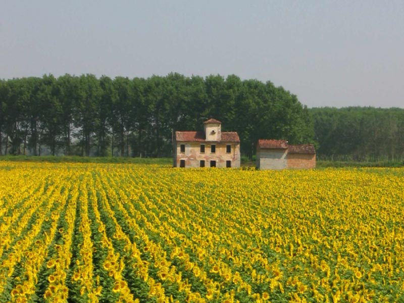
Another
essential element of the Park landscape is the considerable diffusion
of the poplar cultivations. They contribute to the local creation of
green strips, useful fringes between the residual natural areas and the
areas which are more intensively exploited by agriculture.
The
largest surface covered with poplar woods can be mainly found in the
last stretch of the river, in the areas between the low-water riverbed
and the banks: although they are short-turn standardized timber
plantations, they do interrupt the worrying trend towards the reduction
of the forest covering and the monotonous simplification of the
landscape line.
The aims of the Park are to enlarge the surfaces of the natural
environments and to create a continuity between the islands of shrub
and arboreal vegetation. By exploiting the rich network of canals and
waterways in order to spread again tree rows, edges, woodland strips
along the fields, on the slopes and the shores of the river, the
territory would be enriched from an ecological point of view, it would
be subject to a microclimatic rebalancing, and also to a reduction in
the use of irrigation.
In this territory, deeply shaped by the human presence, we can find a
mosaic of ecosystems characterized by various evolution stages,
representing low-land river landscapes whose active conservation is one
of the main aims of the Park Authority. The final stretch of the river
valley, where the river Oglio flows forming several meanders -
characteristic of the low flood plains - is represented by one and only
river canal, deep and set among thin sediments with a sandy-muddy
texture. The edges of the river valley are represented by the
morphological slopes marking the border with the main level - clearly
recognizable by the difference in height. The landscape value of these
slopes is particularly important where they are characterized by a
considerable height and by settlements. These differences in height
reach ten meters in the upstream stretch from Ostiano to Canneto
sull'Oglio, and they are almost meaningless in the last stretch in the
Municipality of Viadana. This last stretch is particularly interesting
as far as the river morphology is concerned, since it is interested by
the action of the two rivers Oglio and Po.
The territory of the river Oglio flood plain is characterized by a thick network of drainage ditches.
The presence of several meanders is one of the main landscape features of Oglio Sud Park.
The areas with natural vegetation are small and fragmented; the six
areas of greatest naturalistic value and mainly representing the Park
environments are:
- Gerra Gavazzi and Runate Oxbows
- Le Bine
- Marcaria Peat Bogs
- Cascina S. Alberto Oxbow
- Belforte Peat Bogs
- Canale Bogina.
Despite the main feature of the Park natural environments is without a doubt their limited extension (given to the intense agricultural activity), they are not isolated, since the presence of the river Oglio and its affluents (ex. Chiese), the thick network of drainage channels, as well as the tree lines and the hedges represent the prodromes of an ecological network which sometimes makes up for the limited extension of the natural environments, favoring the development of the species and guaranteeing the practicability of the territories.
Fauna
As far as wildlife is concerned, the research activities carried out in the Park area have highlighted, like in the rest of the Po Plain, a great impoverishment in the variety of the present animal species.
However, the observations gathered in the Park territory have enabled the survey regarding some statistically important species.
In particular, it is among birds that we can find the greatest variety in species, some of which are also rather rare: the Purple Heron, the Night Heron, the Great White Egret (wintering species), the Osprey (in spring) and the Bittern (wintering species), the Kingfisher, the Bee-eater, etc.
Considerable the presence of Gray Heron, confirmed by the large place where the specimens nest in Marcaria Peat Bog Nature Reserve, and by the one in "Le Bine".
Nineteen species of mammals have been registered; eight certain species of reptiles and seven of amphibians, among which the endemic Italian Agile Frog.
Expert entomologists have highlighted the particular value of the Coleoptera-aquatic fauna found in the Marcaria Peat Bog Nature Reserve, both for the richness in species and for the entity of each population.
The recovery of the territory would favor the wildlife enrichment of the Park.
History of the Territory
The
river and the surrounding territory are rich in remarkable historical
evidences which recall the farthest and most significant epochs.
Near Calvatone (CR) and Acquanegra sul Chiese (MN) the river interrupts
its perfect straight line made of the ancient trail of Via Postumia,
connecting Gena to Aquileia.
In the east of Calvatone, excavations which began several years ago
have brought back to light a Roman settlement, identified as the
ancient Bedriacum (1st century BC - 4th century AD): an archaeological
find which has aroused a considerable interest together with the find
of a great "villa" dating back to the late Imperial age in the
territory of Isola Dovarese.
The vicus of Bedriacum was quoted by writers like Plutarch and Tacitus and some
documents located it at 20-22 miles in the east of Cremona. In the
landscape there are still frequent traces of the Roman settlement,
overlapped by the water and road networks.
The river has always
been an element of attraction, a way of penetration of traffics and
goods, the reference point around which the life of the surrounding
territory was organized. Important evidences of the population
settlements dating back to the Bronze age, and still before, to the
Neolithic period, are well-documented in the municipal museums of
Piadena, Viadana, and Asola. Of extraordinary importance the discovery,
a few years ago, of some one-tree trunk pirogues which have remained
intact in the riverbed and which have been found during the excavations
near Isola Dovarese. However, the period of which we have more
monumental and architectural evidences is the one during which, along
the river Oglio, the Duchy of Mantua and the Duchy of Milan competed
with alternating fortunes.
A series of castles, fortresses, strategic settlements was created to
reinforce the borders. The castle and fortresses of Ostiano, Canneto
and Casatico, the walls of Bozzolo, the wonderful example of late
Renaissance square of Isola Dovarese date back to this period.
A borderland between the territories of Cremona and Mantua, which is
also possible to recognize for the different peculiarities of the
respective agricultural settlements:
- in the area of Cremona, the so-called "corte grande" prevails: it is a quadrilateral areas of buildings with a large courtyard within them. They could be closed by a front door of which, it seems, only the owner had the keys;
- in the area of Mantua, the agricultural estates are much more scattered, the country buildings and the houses are open and placed in different manners, representing also different cultivation techniques, social organization and production regimes.
These evidences of the Po Plain farming
civilization can become the themes for an interesting itinerary, to
follow "by chance" along the municipal and estate roads of the sixteen
Municipalities within the Park.
An ideal route along the river
Oglio cannot miss the visit to a particular "monument" which has become
a symbol of the river, of its history, and of the men who lived and
still live there: the bridge of boats of Torre d'Oglio. The small local
museums (Canneto sull'Oglio, Piadena, Isola dovarese, Viadana and
Asola), the historical museums, the Visitor Centers of the Nature
Reserve "Le Bine" of WWF, the historical town centers, the great number
of country buildings and the natural environments of the Park form a
great heritage of historical and scientific documentation, of knowledge
and beauties, to spread through the sensitization actions and the
didactics promoted by Oglio Park Authority.